Jadual Kandungan
Gonggang / Setapak (1850-an)
Dirujuk oleh
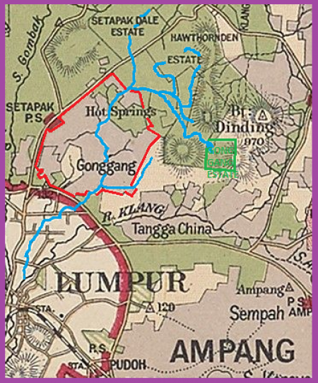
Peta lokasi Gonggang (kawasan kelabu bersempadan merah terang), berdasarkan peta negeri Selangor, tahun 1904 (Edinburgh Geographical Institute, 1904 @ Yale University Library - Digital Collections: |"Selangor, Federated Malay States, 1904 / John Bartholomew & Co ; W.T. Wood, chief draftman").
Umumnya kawasan yang dinamakan “Gonggang” ialah kawasan perlombongan di lembangan Sungai Bunus, di antara Sungai Gombak dan Sungai Klang, termasuk sekitar Taman Tasik Titiwangsa, Air Panas dan Setapak Jaya kini. Manakala “Kampung Gonggang” pula mungkin merujuk kawasan-kawasan petempatan kediaman dan perkebunan di kawasan yang berhampiran dengan pusat bandar Kuala Lumpur. Kampung ini meliputi sehingga ke Tanah Perkuburan Jalan Ampang (dahulu Perkuburan Gonggang) di sebelah selatan, Kampung Datuk Keramat di sebelah timur, dan bersempadan dengan KEMENTAH (dahulu Rifle Range) di sebelah timur laut.
Gonggang di lembangan Sungai Bunus (merujuk peta 1904 di atas): “Sungai Bunus mempunyai kawasan tadahan seluas 17 kilometer persegi meliputi kawasan Wangsa Maju dan Setiawangsa. Dua anak sungai utamanya ialah Sungai Air Panas yang mengalir dari kawasan tadahan Wangsa Maju dan Sungai Peran meliputi kawasan tadahan Setiawangsa.” (Jabatan Pengairan dan Saliran Malaysia, 2020: |"Laporan Tahunan 2020", m.s.88).
Kampung Gonggang di Kuala Lumpur: “In Kuala Lumpur and its surroundings, the status of Muslim endowments and burial ground was precarious. The Sanitary Board of Kuala Lumpur was formed in 1900, and one of its first tasks was to relocate cemeteries away from the populated town centre, for reasons of public health. In 1891, the large Muslim burial ground near the confluence of Gombak and Klang rivers was cleared, fenced up, and supposedly exhumed. As it turned out, not all the graves were disinterred; some remained in the compound of the Masjid Jamek right up till the twenty-first century. A new cemetery was established just outside town at Ampang Road. ('The public Mohamadan Cemetery is on the other side of the Klang River near Ampang Road. A strong six feet bridge was erected to give necessary access to it.' A. Hale, vice chairman of the Kuala Lumpur land office, as reported in the Malay Mail, 13 April 1904, reproduced in Khoo Kay Kim, Kuala Lumpur, 27.) It was originally called Tanah Perkuburan Kampung Gonggang, as it was located near the settlement of orang Gonggang (a subgroup of orang Siak). (This Kampung Gonggang is different from the Gonggang settlement near Setapak. Interview with Haji Shahrir Kamil, 30 November/1 December 2016).” (Abdur-Razzaq Lubis, 2018: "Sutan Puasa, Founder of Kuala Lumpur", m.s. 505).
Kampung Datuk Keramat sebahagian daripada Kampung Gonggang: “Jalan Datuk Keramat: This road lies within the village of Datuk Keramat, which was once part of Gonggang and Kampung Tangga Cina. The 170-acre area was declared a Malay Reserve in 1957. … Sources: Ani 2000 (Ani binti Ahmad (2000), Tanah Rizab Melayu di Wilayah Persekutuan Kuala Lumpur: Satu Kajian Kes terhadap Aspek Perumahan di Kampung Dato' Keramat, Kuala Lumpur: Universiti Malaya):141-145; Dewan Bahasa 1995 (Dewan Bahasa & Pustaka (1995), Ensiklopedia Sejarah dan Kebudayaan Melayu Jilid 2, Kuala Lumpur: Dewan Bahasa dan Pustaka): 1076” (Mariana Isa, Maganjeet Kaur, 2015: "Kuala Lumpur Street Names: A Guide to Their Meanings and Histories", m.s. 87).
Kronologi Sejarah
1850-an: Gambaran Suasana Prakolonial
Menurut catatan Raja H.M. Yacob berjudul “Tarikh Raja Asal dan Keluarganya” (1934), Gonggang (ditulis sebagai Gerongkang) dibuka sekitar tahun 1855, oleh Hulubalang Ali (salah seorang ketua di bawah Sutan Puasa/Naposo). Berikut adalah latar peristiwa pembukaan Gonggang, menurut riwayat ini:-
“Di dalam umurnya lebih kurang empat puluh tahun dengan takdir Allah zaman diiringi oleh kusmatnya; pada tahun lebih kurang 1840 M[asehi]; ia (Raja Asal) pun bertawakal'alallah meninggalkan watannya, tujuan merantau ke negeri Pahang. Ia-lah hajat ikhtiar mencuba untung nasibnya, kerana negeri Pahang itu termasyhur ke Pulau Perca. Maka banyaklah orang-orang dari Sumatra datang merantau masuk ke situ, daripada bangsa Minangkabau, Rawa, Mandailing dan lainnya. Adalah usaha mereka berkelian emas di daerah Raub (Hulu Pahang) yang menjadikan gemoh ke seberang sana.
Ada-lah jalan yang dilalui oleh Raja Asal, mulanya masuk ke negeri Rawa, Pandalian, Tandun, Kasipekan, Patapahan, Pantai Cermin, Pekan Baharu dan Bengkalis; kemudian menyeberang ke Melaka. Dari situ ke Sungai Hujong, akhirnya sampai ke Pahang. Maka bertemulah ia dengan orang-orang Sumatra dan bangsa-bangsanya, seperti Raja Mangasa Pidoli Bukit (seorang yang terkenal) masa itu, dan Bendahara Raja (seorang ketuha)(1), Sutan Magah(2), Jalumut(3), Jasuman(4), Pinta Ali, Jabaringin, Jagaringking, Angku Tuha, Jakalon dan banyak lagi yang lain-lain.
Maka Raja Asal pun berusahalah bersama-sama mereka itu berkelian emas, dan juga setengah yang lain-lain, hingga sampai ke Sungai Hujong. Demikianlah halnya sampai berpuluh tahun.
Kemudian termasyhur pula khabaran negeri Selangor boleh didapati banyak timah, dan murah pula mencari rezeki yang lain; lebih baik daripada tempat mereka itu. Maka bermuafakatlah mereka lalu pindah ke Selangor, lebih kurang di dalam tahun 1855 M., dan dibuka mereka tempat daerah Hulu Kelang, berhampiran Kampung To' Naga.
Di situlah bersawah dan kampung, berteranak hidup-hidupan. Semakin lama bertambah-tambah orang Mandailing dan lainnya masuk ke Hulu Kelang. Dan yang mana diam Kuala Lumpur, berniaga timah hingga sampai ke Melaka. Dan yang di Hulu Kelang, berusaha membuka kelian timah dan melampan (melereh). Adalah saudagar-saudagar orang Mandailing yang terkenal pada masa itu: “Sutan Puasa”, Jalila, Jasuman, Haji' Abdul Majid(5). Dan ketuha mereka di Kuala Lumpur, Raja Dori.(6).
Dan dibuka mereka pula tempat-tempat seperti di Ampang, diketuhakan oleh Raja Baranang, akhirnya Raja Banding(1); di Bunus diketuhakan Jabaltuq(2) (atau To' Bunus); di Gerongkang ('Gerongkang', merujuk kepada Gonggang di Setapak, asalnya daripada perkataan gronggang, iaitu membuat terowong dalam usaha perkelianan), Hulubalang Ali; di Kajang, Raja Barayun(3); di Hulu Langat; Angku Tuha (4); dan ada yang lain-lain tiada teringat nama-namanya.”
(Sumber: Abdur-Razzaq Lubis, 2021: "Tarikh Raja Asal: Derap Perantauan Kaum Mandailing dari Sumatra ke Tanah Semenanjung", m.s. 127-129).
Menurut riwayat Abdullah Hukum tentang kehidupan awalnya di Kuala Lumpur (termasuk Setapak/Gonggang) sekitar 1850-an, beliau turut menyatakan Sutan Puasa dan para pemimpin Mandailing sebagai ketua-ketua di sekitarnya ketika itu:-
“Pada masa saya berumur kira-kira 15 tahun saya dibawa berdagang oleh ayahanda saya meninggalkan negeri. Kami keluar dari tanah Sumatera melalui Pekan Baharu (Siak) dengan sebuah sekoci belayar menuju tanah Semenanjung dan menempat ke Melaka pada tahun 1850. …
Setelah berhenti tiga hari lamanya di Melaka itu, maka kami pun belayar pula dengan sebuah nadil menuju Pengkalan Kempas. Nadil yang kami tumpang itu memunggah kain dan barang-barang lain di Pengkalan Kempas. Kami pun naik ke darat. Saya mengambil upah menggalas kain dari Pengkalan Kempas ke Sungai Ujong. Upahnya sekati lima sen sahaja dari seorang saudagar kaya orang Kerinchi bernama Haji Abdul Rahman. Dengan jalan itulah kami sampai di Sungai Ujong.
Berhentilah saya di Sungai Ujong selama lapan hari dengan maksud hendak mencari pekerjaan tetapi tak dapat. Masa itu Sungai Ujong belum masuk di bawah perintah Inggeris dan pemerintahnya ialah Almarhum Datuk Kelana Sendeng namanya. Cina telah ada membuka lombong di situ dan sebab tiada pekerjaan maka kami pun beredar menuju Kuala Lumpur kerana kata-kata orang banyak pekerjaan di Kuala Lumpur boleh bertanam sayur dan boleh melampan.
Ketika itu ada pula kumpulan orang Inggeris menggalas kain hendak berangkat ke Kuala Lumpur, maka kami tumpanglah kumpulan itu. Berjalan ikut berjalan dan berhenti ikut berhenti pula. Adapun jauhnya perjalanan itu ialah tiga hari tiga malam. … Akhirnya, kami pun sampailah di Kuala Lumpur lalu menumpang di rumah Haji Abdul Ghani orang Air Bangis berkedai (Java Street sekarang).
Pemandangan di Kuala Lumpur
Kuala Lumpur pada masa itu sibuk cara zaman dahulu. Ada dua lorong sahaja, iaitu Java street dan Market Street sekarang manakala Ampang Street (Lorong Ceti) yang ramai sekarang ini masih kolam ikan dipunyai oleh Almahrum Sutan Puasa.
Rumah-rumah kedai masa itu atap bertam dinding pelupuh (buluh) dan orang yang berniaga di situ seperti menjual kain-kain dan makanan semuanya orang Melayu, iaitu bangsa Rawa dan Mendahiling dan ketuaan masa itu ialah Sutan Puasa dan Raja Bilah. Kedua-dua ketua ini mengutip hasil dagangan yang lalu lintas melalui Sungai Kelang atau Sungai Gombak. Adapun cukai timah ialah seringgit sebahara (tiga pikul).
Ada pun Setapak sekarang di hulu Sungai Tapak namanya dan Hulu Gombak sekarang Air Panas namanya. Maka Sutan Puasalah yang membuka sawah pada kedua-dua tempat ini. Tuan Haji Abdullah Hukum berkata lagi - saya ingat mengambil bahagian mengambil upah membuat tali air di Serambut (Batu Lima Setapak sekarang) dan juga di tempat-tempat lain diupah oleh Sutan Puasa.
Sawah yang dibuka Sutan puasa itu mudah sahaja. Apabila tali air sudah siap maka orang ramai barang siapa sahaja boleh membuat sawah tetapi syaratnya hendaklah membayar cabut 10 gantang padi pada tiap-tiap seratus gantang (10 peratus) kepada Sutan Puasa apabila habis musim menuai. Kiraan membayar cabut itu tidak begitu keras hanya mengikut pengakuan masing-masing orang yang bersawah sahaja. Pendeknya berapa yang dihantarkan orang kepadanya itulah diterimanya.
Lepas daripada mengambil upah membuat tali air itu saya melampan di Setapak berkekalan kira-kira tiga tahun lamanya. Masa itu tiada apa-apa huru-hara dalam Kuala Lumpur. Semua orang Melayu tinggal dalam aman dan tetuaan semuanya orang Mendahiling.”
(Adnan Haji Nawang, 1997: "Kuala Lumpur dari Perspektif Haji Abdullah Hukum", m.s.14-17).
1870: Antara Lokasi Perang Klang (1867-1874)
Gonggang adalah antara lokasi Perang Klang (1867-1874):-
“Nama Gonggang dipercayai telah disebut seawal tempoh ketika berlakunya Perang Saudara Selangor atau Perang Klang yang meletus pada 1867 – 1874. Pada waktu itu, lokasi yang disebut sebagai Gonggang ini digunakan sebagai laluan ke Kuala Lumpur untuk menyerang dan berundur ke Pahang dan Kuala Kubu di Ulu Selangor oleh tentera yang menyokong Raja Mahadi. Berdasarkan semakan sejarah, antara lokasi yang menggunakan nama Gonggang adalah berikut:
1. Kawasan Perkuburan Kg Gonggang (Kini dikenali Tanah Perkuburan Jalan Ampang yang terletak di sebelah KLCC)
2. Kg Gonggang (Kini dikenali sebagai Kg Datok Keramat, Kuala Lumpur)
3. Ladang Getah Gonggang Estate (Kini telah dibangunkan dan dikenali sebagai Setiawangsa)
Sehingga kini, para sejarawan masih berdebat dan sedang menjejak lokasi kg Gonggang di mana terletaknya makam Raja Laut iaitu Kerabat Diraja Selangor yang menjadi Penghulu dan Majistret di Kuala Lumpur. Walaupun dipercayai beliau dikuburkan di Tanah Perkuburan Jalan Ampang, para sejarawan mempercayai bahawa terdapat kawasan perkuburan Diraja terletak di sekitar Gonggang di mana para kerabat Diraja dan raja-raja kerajaan lama terdahulu dimakamkan. (sebelum Kesultanan Selangor bermula). Namun disebabkan oleh pembangunan pesat di Kuala Lumpur, lokasi makam tersebut mungkin sudah ditelan pembangunan ataupun telah dipindahkan ke lokasi lain yang tidak diketahui.”
(Sumber: Budak Wangsa Maju, 23 September 2018: |"Gonggang: Nama yang hilang di Setiawangsa").
Pertempuran di Gonggang
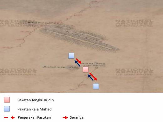
Pada tahun 1870, kawasan sekitar Gonggang pernah menjadi salah satu lokasi pertempuran dalam siri Perang Kelang / Perang Saudara Selangor di antara kumpulan Tengku Kudin dan Yap Ah Loy (Raja Abdullah) dengan kumpulan Syed Mashhor dan Chong Chong (menyebelahi Raja Mahadi). Di dalam salah satu babak pertempuran tersebut, pasukan Syed Mashhor telah menyerang pasukan Yap Ah Loy (diketuai Hiu Fatt and Tung Khoon) di Ulu Klang dari Ampang, manakala pasukan Chong Chong mara dari sebelah barat Bukit Dinding (yang kemudiannya menjadi Ladang Gonggang dan Hawthornden), lalu mengepung pihak lawan dari belakang, kemungkinan dari lembah Sungai Gisir di sebelah utara Bukit Dinding. Namun pasukan Yap Ah Loy yang lain (diketuai Chung Piang) sempat sampai ke lokasi kepungan dan setelah pertempuran yang panjang, berjaya mematahkan serangan lalu memaksa pasukan Chong Chong berundur kembali ke Ampang:-
“Ketika aku sedang menelaah tentang sejarah Perang Saudara Selangor atau lebih dikenali sebagai Perang Kelang, aku telah terbaca satu artikel sejarah yang menarik yang berkaitan dengan lokasi di Wangsa Maju iaitu Bukit Dinding. Tulisan artikel ini memaparkan kisah siri perang Kelang yang berlaku pada 1870 dan lebih dikenali sebagai The Battle of Ampang. Tulisan artikel ini agak menarik berikutan ia melibatkan sedikit kawasan Wangsa Maju iaitu di sekitar kawasan Bukit Dinding dan kawasan Lembah Sungai Gisir, Hulu Kelang.”
…..
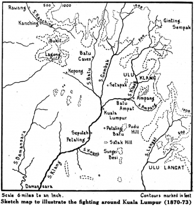
Kiri: Peta sekitar Kuala Lumpur, 1870-1873 (S. M. Middlebrook, J. M. Gullick and C. A. GIBSON-HILL @ Journal of the Malayan Branch of the Royal Asiatic Society, Vol. 24, No. 2 (155), July 1951: |"Yap Ah Loy (1837-1885)", m.s.54).
Kanan: Peta sekitar Bukit Dinding, tahun 1883 (Budak Wangsa Maju, 21 April 2018: |"Sejarah Wangsa Maju: The Battle of Bukit Dinding, The Forgotten War of Perang Kelang").
“In the meantime, Hiu Fatt and Tung Khoon had returned to their improvised camp at Ulu Klang. During the night, much to the surprised of Hiu Fatt and his men, they were woken up by sounds of firearms and shouting, and discovered that Mashhor’s force were in front of their position. Without hesitation, Hiu Fatt immediately gave orders for a direct attack to be made on the enemy. While the fighting was in progress, Chong Chong’s army emerged from the rear of Hiu Fatt's position (presumably along the north flank of Bukit Dinding and down the valley of the Sungei Gisir), thus Hiu Fatt and his men were trapped between two larger units of enemy forces.'” (Kongsi NetWorks, 2000: |"The History of Yap Ah Loy, Kapitan Cina of Kuala Lumpur and Klang (1867-1885)", m.s.24).
“Syed Mashoor telah meminta bantuan daripada Pasukan Chong Chong untuk menyerang Pasukan Yap Ah Loy yang kini telah berkubu di Ulu Kelang. Seramai 600 orang askar Pasukan Chong Chong telah dihantar untuk tujuan tersebut dan mereka berkubu di kawasan Lembah Sungai Gisir di Utara Bukit Dinding. Pada waktu malam tanpa disedari oleh Hiu Fatt and Tung Khoon, Pasukan Syed Mashoor telah menyerang mereka secara serang hendap manakala Pasukan Chong Chong pula menyerang mereka dari arah belakang. Keadaan ini menyebabkan Pasukan Yap Ah Loy terkepung dari arah depan dan belakang.” : “Mashhor himself made his way to Chong Chongas camp near Batu Ampat, and suggested an immediate counter-attack, before Ah Loy's men could consolidate their position. Chong Chong agreed with the proposal and Jhat night led a force estimated at about 1,000 men towards Ulu Klang. Mashhor is said to have- followed him with an equal force, but advancing by a different route. There is actually only one direct line of approach from Ampang to Ulu Klang, that is up the river valley. It seems probable that Mashhor took this course (he had just retreated along it), while Chong Chong made his way round through the present Gonggang and Hawthornden Estates, to the west of Bukit Dinding. In the meantime Hiu Fatt and Tung Khoon had returned to their improvised camp at Ulu Klang. During the night they were woken by sounds of firearms and shouting, and discovered Mashhor's force in front of their position. They immediately gave orders for a direct attack to be made on the enemy. While it was in progress Chong Chong's men came up from the rear, presumably along the north flank of Bukit Dinding and down the valley of the Sungei Gisir. The Capitan China's men were thus trapped between two larger units of the enemy. Fortunately Ah Loy had decided that evening to re-inforce his troups at Ulu Klang, and had sent Chung Piang out to them with 400 men. These arrived in the middle of the conflict, and presumably in the rear of Chong Chong's encircling force. After a long struggle, in which the Capitanas losses amounted to over 40' killed and 100 wounded, Chong Chong was forced to retreat to his stockade at Ampang, “after sustaining a heavy loss”..” (S. M. Middlebrook, J. M. Gullick and C. A. GIBSON-HILL @ Malaysian Branch of the Royal Asiatic Society (MBRAS), July 1951: |"Yap Ah Loy (1837-1885)", m.s. 56).
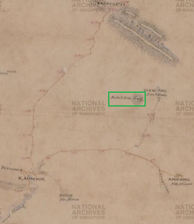
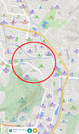
Kiri: Peta Bukit Dinding (dalam petak hijau) dan sekitarnya, berdasarkan peta tahun 1883: “Roads And Tracks Radiating From Kuala Lumpur, And Klang River, Malaya, 1883. Sketch Map shows K. Lumpor (Kuala Lumpur), parts of Klang River, landscape, hilly forests, hill names, hill hachures, roads, tracks, milestones, tin mines at Ulu Klang, Ampang, Pugu and Pataling (Petaling), police stations at Anak Ayer Batu, Kabu Lada and Damansara, tracks, swamps, river and clearings, Klang River, river bank, villages, Ginting Bidei, Klang Gates and others.” (Survey Department, Federated Malay States (F.M.S.) and Straits Settlements (S.S.), 1883 @ National Archives of Singapore: |"Roads And Tracks Radiating From Kuala Lumpur, And Klang River, Malaya").
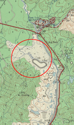
Tengah: Lembah Sungai Gisir, 1967 (Bulatan merah), berdasarkan peta Malaysia : Director of National Mapping, 1967: |"Malaysia, Selangor, Kuala Lumpur, Series: L8010, Sheet 94k, 1967, 1:25 000").
Kanan: Lembah Sungai Gisir, kini (Bulatan merah), berdasarkan peta Mapcarta.
Yap Ah Loy kemudiannya meminta bantuan Raja Asal dari Damansara untuk membantu pasukannya menyerang kubu Raja Mashhor (diketuai Chong Chong dan Che Soho) di Ampang. Raja Asal bersetuju, dan beliau bersama pasukannya bertindak mengepung kubu tersebut: Hiu Fatt dan Tung Khoon dari barat (Kuala Lumpur), Sutan Puasa dari timur laut (Ulu Klang), dan Teng Sam dari tenggara (Ulu Langat). Setelah sebulan dalam kepungan, pasukan Chong Chong dan Che Soho bertindak merempuh kepungan di Bukit Gonggang (kemudiannya selatan Ladang Gonggang) di sebelah barat. Setelah pertempuran yang sengit dan melibatkan banyak korban di kedua belah pihak, akhirnya mereka berjaya melarikan diri ke arah Batu Caves: “The forces were well disposed, but they left two outlets uncovered.. Hiu Fatt and Tung Khoon were attacking from the west, along the line of the present road from Kuala Lumpur to Ampang. Asal and Sutan Puasa to the north-east prevented a retreat to Ulu Klang, while the small force under Teng Sam covered the way over to Ulu Langat. Two courses still lay open to Chong Chong if he could not hold his position. One was to withdraw south over soft ground towards Pudu Ulu, and thence down to Kuala Langat. The other was to strike north-west over the spur of the diminutive Bukit Gonggang (through the southern fringe of the present Gonggang Estate). ….. The battle began about 10 in the morning: an early start never seems to have been popular. By the late afternoon Chong Chong's forces “were routed with the loss of five hundred men…. having not been able to defend both directions. Those who were wounded were numerous. By nightfall Chong Chong and Che Soho, realising the dangerous position they were in, were compelled to flee in the direction of Batu Caves by way of Gonggang (Setapak). The dead bodies of men and horses lay in piles in the waste, and blood was flowing like streams. Both had the intense hatred for the defeat. …” (Source 3, sheet 3 6).” (S. M. Middlebrook, J. M. Gullick and C. A. GIBSON-HILL @ Malaysian Branch of the Royal Asiatic Society (MBRAS), July 1951: |"Yap Ah Loy (1837-1885)", m.s. 57).
“Sejarah Bukit Dinding ini telah direkodkan seawal 1870 dan telah dipetakan oleh British pada 1883 berikutan terdapat aktiviti pembukaan lombong bijih timah di Ulu Kelang oleh Raja Abdullah.
…..
136 tahun selepas pertempuran ini berlangsung, aku telah cuba untuk menjejak kesan peperangan ini. Tidak banyak cerita yang diketahui berkenaan pertempuran Bukit Dinding ini (The Battle of Bukit Dinding) di dalam internet dan juga buku sejarah melainkan daripada rekod sejarah Yap Ah Loy. Namun begitu, peristiwa The Battle of Bukit Dinding ini seharusnya direkodkan sebagai satu sejarah Wangsa Maju dan menunjukkan bahawa Bukit Dinding di Wangsa Maju ini menjadi saksi keterlibatan kawasan ini di dalam peristiwa sejarah Perang Kelang atau Perang Saudara di Selangor.”
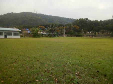
Kiri: “Kawasan Padang di AU4 yang terletak di lembah Sungai Gisir, Hulu Kelang. Adalah dijangka di sinilah berlakunya pertempuran The Battle of Bukit Dinding di antara Pasukan Yap Ah Loy dan Pasukan Chong Chong / Syed Mashoor, Kawasan lapang ini terletak berhampiran dengan Sungai Gisir dan dahulunya terdapat kawasan perkampungan Melayu di sini yang dikenali sebagai Kampung Seri Lembah Keramat. Namun begitu tapak pertempuran sebenar masih tidak diketahui berikutan tiada rekod asal ditemui di dalam rekod sejarah dan kawasan sekitar Bukit Dinding dan Sungai Gisir juga telah dibangunkan dengan pesat.”
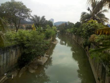
Kanan: “Sungai Gisir di Lembah Keramat, Ulu Kelang. Kini telah menjadi longkang besar atau monsoon drain di lokasi. Pada waktu dahulu, Sungai Gisir ini dipenuhi dengan sumber bijih timah dan menarik perhatian Raja Abdullah untuk melombong di sekitar kawasan Sungai Gisir ini. Kesan lombong bijih timah ini telah pun hilang di dalam lipatan sejarah dan kawasan Ulu Kelang kini telah pesat membangun tanpa sedikit pun sebarang kesan sejarah yang ditinggalkan di sini.”
(Sumber: Budak Wangsa Maju, 21 April 2018: |"Sejarah Wangsa Maju: The Battle of Bukit Dinding, The Forgotten War of Perang Kelang").
1880-an: Permulaan Era Kolonial
Sawah dan Dusun
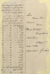
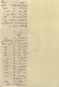
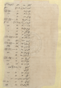
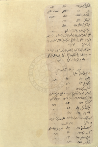
Pada awal penglibatan kolonial British, mereka telah mengumpulkan maklumat sawah padi dan dusun-dusun di sekitar Kuala Lumpur, termasuk sekitar Setapak (Gonggang). Berikut adalah contoh laporan tinjauan sawah dan dusun oleh Imam Perang Perkasa, meliputi kawasan Tangga China (sebahagian daripada Kampung Gonggang, kini sekitar Kampung Datuk Keramat), Hulu Klang, Setapak, Sungai Mulia, Segambut, dan Gombak, termasuk luas setiap satunya, bagi tahun 1294-1296H (1877-1879M). Laporan disediakan oleh Raja Shaaban dan keraninya:-
“Lies(List) Kiraa-Kiraa(Kira-Kira) Ocorand(Ukuran) Imam Perang Perkassa - Tangga China - Hulu Klang - Sitapak(Setapak) - Sungei Mulia - Sigambout(Segambut) - Gombaks(Gombak)
….
Maka adalah sahaya Raja Sha'ban dan kerani Muhammad Ja'im(?) dan mata-mata Klang(?) bernama Sutan Majalela(?) ? orang ada periksa(?) fasal(?) sawah dan dusun sudah diukur Imam Perang Perkasa ? ? orang2 lelaki di dalam Tangga Cina ? ? mula2 Encik ? - yang - ? - Siti ? - ? - anak buah Encik ? - ? - $10 dusun(?) tinggi dusun(?) ? $7 sudah terima Imam Perang Perkasa ? - -
….
Nombor - 4 : Sitapak (Setapak)”
| Nama | Panjang sawahnya (depa) | Lebarnya (depa) | Dapat padi (gantang) |
|---|---|---|---|
| Sutan Puasa | 150 | 100 | Baharu ada dusun ? ? ? terkurung dalam kawasan Sutan Puasa tahun 1295 |
| Penikar(?) Ambun(?) | 110 | 105 | 300 |
| Khatib Muda | 100 | 40 | 1200 |
| Pungkut | 100 | 40 | 500 |
| Blngami(?) | 100 | 45 | 600 |
| Sibatu(?) | 100 | 50 | 800 |
| Sibatu(?) Juga | 100 | 50 | Baharu |
| Prisuti(?) | 100 | 60 | 700 |
| Mataib(?) | 80 | 35 | 500 |
| Panglima Suti | 100 | 33 | 500 |
| Haji Muhamad ? | 100 | 35 | Baharu |
| Situli(?) | 100 | 20 | 300 |
| ?jlng(?) | 100 | 70 | 700 |
| ? dusun ? | 100 | 70 | |
| Sutan Jrnim(?) | 100 | 90 | 600 |
| Raja Men(?) Dusun kundang | 100 | Bujur(?) | |
| Sitaim(?) | 40 | 35 | 100 |
| Tengku Muda dusun yrmu(?) | 14 batang | #3- | |
| Ptlima(?) Dalam | 140 | 30 | 1294:800, 1295:800 |
| Malim Sutan | 70 | 30 | Baharu |
| Haji Lati(?) | 55 | 30 | Baharu |
| Haji Abdul ? | 40 | 30 | 1294:600, 1295:700 |
| Malim Prajan(?) tidak berjumpa orangnya(?) | $1-30 | ||
| Paduka ? | 50 | 40 | Baharu |
| Haji Muhamad Salih | 45 | 40 | Baharu |
| Haji Ibrahim | 70 | 14 | Baharu |
| Malim ? | 50 | 180 | Baharu |
| Tr'(?) Melaka | 50 | 180 | 1294:1000, 1295:1000 |
| Simpan(?) | 125 | 55 | 500 |
| ? | 120 | 50 | 1294:250, 1295:250 |
| Tok Siamang(?) | 130 | 140 | 800 |
| Labi Mju'(?) | 100 | 60 | 1294:300, 1295:800 |
| Haji Abdullah | 90 | 40 | Baharu |
| Abdul Fa(?) | 100 | 16 | Baharu |
| Simulia(?) | 55 | 19 | 1294:300, 1295:500 |
| Malim Selawat | 45 | 21 | 100 |
| Faqir ? | 40 | 48 | Baharu |
| Sitmlng(?) | Tidak berjumpa pergi ke hutan | ||
| Penekar Liman(?) | Tidak berjumpa pergi ke hutan | ||
| ? Ibrahim | 90 | 60 | Baharu |
| Spkut(?) | 70 | 30 | Baharu |
| Sitam(?) sawah dan kebun | 100 | 35 | Baharu |
| Sitbali(?) | 61 | 41 | 1295:40 |
| Fatih Hmd(?) | 67 | 40 | Baharu |
| Tukang Kecil(?) | 110 | 30 | Baharu |
| Omar | 80 | 30 | 400 padi |
| Panglima Muda | 136(?) | 40 | Baharu |
| Singgar(?) | 32 | 12 | Baharu |
| ? | 40 | 30 | Baharu |
| Tok ? | Belum ber? sawahnya | Baharu |
(Sumber: Arkib Negara 1957/0000991W, 01/09/1879: |"RAJA SHABAN'S REPORT: DETAILS ON THE MEASUREMENT AND SURVEY WORKS OF PADDY FIELDS AND ESTATES IN THE STATE.").
CATATAN
Raja Shaaban
Raja Shaaban yang menyediakan laporan ini adalah ketua suku Minangkabau bagi daerah Ulu Klang dan Ulu Langat, 1879-1881:-
- Raja Shaaban telah terlibat di dalam Perang Klang sekitar 1870-an sebelumnya, yeng menyebelahi pihak yang menang (Tengku Kudin): “No mention of Mandailing individuals was registered in Douglas's diary, possibly because, after their final fall from grace in 1875, the community was left with no spokesperson of any standing. In comparison, the victors of the Klang War were much better off. Tunku Kudin's and Davidson's men were ensconced in a strong position in Kuala Lumpur. Apart from Dato' Dagang Nonggok, Kapitan China Yap Ah Loy, towkay Yap Ah Shak, and another prominent Chinese leader, there were two Minangkabau leaders, Raja Shaaban and Dato' Sati.” (m.s. 459).
- Setelah itu, ketika perpindahan pusat pentadbiran British dari Klang ke Kuala Lumpur, Raja Shaaban ditugaskan menyelia pembinaan kota Bukit Nanas yang baru: “The growth of British colonial influence in the state of Selangor enabled the colonialists to shift their geographical base from the coast to the interior. Sultan Abdul Samad's visit set the stage for the transfer of Selangor's capital from the estuarial port of Klang to the tin-rush town of Kuala Lumpur, the center of wealth production and population growth. The colonial authorities initially built a courthouse, together with a police station and resthouse to accomodate government officers from 'outstation'. These buildings were relocated piece by piece, from Klang, and reassembled on Bukit Nanas and elsewhere in Kuala Lumpur. As the colonial administration felt that its position was insecure, a pentagonal fort was built on Bukit Nanas to protect its skeletal workforce. Raja Shaaban superintended the construction of the new fort, and Sultan Abdul Samad placed the first pole 'with Malayan ceremony'. As the administration expanded, the cluster of government buidings called 'the Fort' became known as the 'Government Offices' and 'Public Offices'. These structures were built on the well chosen site of 'Sutan Puasa's stockade', with access to natural spring, and a commanding view of the town. The war had destroyed most of the former Mandailing settlement, and the construction of this new infrastructure probably wiped out any remaining traces.” (m.s. 462).
- Raja Shaaban menggantikan Sheikh Muhammad Ali sebagai ketua kaum minangkabau bagi Ulu Klang dan Ulu Langat pada tahun 1879, sehingga kematiannya pada 1881: “A large group of Minangkabaus in Kuala Lumpur originally came to Klang as followers of the two Minangkabau fighting chiefs, Sheikh Muhammad Taib and Sheikh Muhammad Ali, who had worked closely with Tunku Kudin and Davidson. Their story is known from a petition presented by 84 Minangkabaus to the British Resident in 1880, seeking the appointment of Haji Abdulsamat as penghulu of Kuala Lumpur. Residing in 'Negeri Klang' since 1870, the Minangkabaus had been 'eking out a meagre living' (mencarikan hal miskin jalan kehidupan); some by cultivating dry paddy and wet rice, and some by mining tin (jebak kalian), trading, or opening shops. They had come to settle in Klang by following Sheikh Muhammad Taib, abiding by his leadership until 1875, when he left for Perak. From then on, they followed Sheikh Muhammad Ali, as he could render meaning (memberi erti) to government regulations and edicts for them, and forward their requests to the authorities. … When Sheikh Muhammad Ali died in June 1879, his position in both Ulu Klang and Ulu Langat was filled by Raja Shaaban, a known supporter of Tunku Kudin. Raja Shaaban died shortly afterwards, in 1881, and was replaced by Haji Ibrahim, the leader of the 1880 petition.” (m.s. 474-475).
Imam Perang Perkasa
Mungkinkah Imam Perang Perkasa ini adalah Penghulu Kuala Selangor sekitar 1880-an?
- Rumahnya berhadapan Sekolah Melayu Kuala Selangor (SK Kuala Selangor kini): “Lebih kurang 7 tahun sebelum 1891, iaitu dalam pemerintahan Sultan Abdul Samad (1857-1898), Sekolah Melayu Kuala Selangor telah didirikan di Pekan Pasir Penambang, Kuala Selangor, Selangor. Demikianlah dinyatakan oleh Haji Husin bin Mapak, 9(?) tahun, murid tua sekolah ini ketika ditemui dirumahnya di Kg Ujong Permatang, Kuala Selangor. Ditanya tentang tapak sekolah ini beliau berkata “Depan injin kelapa, dekat rumah Dato' Penghulu Imam Perang Perkasa dan Pengurus Ladang Kelapa Orang Putih (Inggeris). Masa itu sambung beliau “Laut jauh lagi ke sana”. Pada masa itu, feri belum ada lagi, orang-orang Kuala Selangor semua belajar di situ. Bila ditanya “Bagaimana murid-murid datang ke sekolah?”, Haji Husin menjawab “Mereka naik sampan kolek”.” (Unit Pengurusan SEKLAS/2023-2024: "Buku Pengurusan Sekolah Kebangsaan Kuala Selangor 2023", m.s. 19).
- Surat minta cuti 2 bulan, untuk ke Sumatera (Arkib Negara 1957/0072312W: |"IMAM PERANG PERKASA HAJI M' ARIPH, PENGHULU KUALA SELANGOR - APPLICATION FOR TWO MONTHS' LEAVE TO GO TO SUMATRA, TRANSMIT -").
Perlombongan
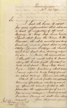
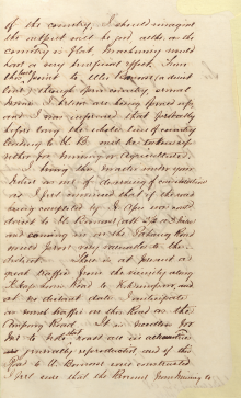
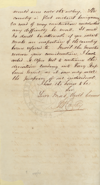
Ketika peringkat awal campurtangan Inggeris pada tahun 1880-an, kawasan lembangan Sungai Bunus yang dikenali sebagai “Gonggang” (kemudiannya Setapak) telah pun menjadi antara pusat perlombongan bijih timah. Ia beransur berkembang sehingga ke hulu Sungai Bunus, iaitu di sekitar Wangsa Maju kini. Keadaan ini ada direkodkan di dalam sepucuk surat bertarikh 24 September 1883, daripada juruukur M'Carthy kepada H.F.Bellamy, ketika beliau mencadangkan pembinaan jalan baru bagi menghubungkan kedua-dua lokasi tersebut:-
“I have the honor to report for your information that while on a visit of inspection of the road leading to Kong Yap Soon's mine I heard that from this mine to the Boonoose, the whole country was being opened up and a great deal is(?) working orderly. Chinese towkays who have some time past been turning out good tin ore. Under the circumstances I thought it worth while to proceed along the bridle path for about a mile or so past Kong Yap Soon's mine. After proceeding about 400 yds I came upon a mine lately opened on which many Chinese were working. About 1/2 a mile further on, extensive mining operations are being carried on & from the number of sheds ? this place has the appearance of a promising village. I noticed several hundred Chinese at work here & busily engaged. From the general appearance of the country, I should imagine the output will be good, altho, as the country is flat, machinery would have a very beneficial effect. From this last point to Ulu Boonoose (a direct line) through open country, several mines I believe are being opened up, and I was informed that probably before long the whole line of country leading to U. B. will be taken up either for mining or agriculture. I bring this matter under your notice as one of deserving of consideration as I feel convinced that if the road being completed by Sr. Akes(?) was contd. direct to U. Boonoose (abt. 2 1/2 or 3 miles) and coming in on the Pahang Road would prove very valuable to this district. There is at present a great traffic from the vicinity along K Yap Soon's Road to K. Lumpur, and at no distant date I anticipate as much traffic on this road as the Ampang Road. It is needless for me to note that roads are in all countries generally reproductive, and if this road to U. Boonoose were constructed I feel sure that the revenue from mining would soon cover the outlay. The country is flat without being swampy & a road of easy construction could without any difficulty be made. It should no doubt be advisable if you were to make an inspection of the country herein referred to. Until this matter receives your consideration, I have asked Sr. Akes(?) not to continue the deviation leading into Kong Yap Soon's mine, as it can only serve the purposes of one individual.”
(Sumber: PEJABAT SETIAUSAHA KERAJAAN NEGERI SELANGOR, 24/09/1883: |"CONSTRUCTION OF GONGGANG ROAD TO ULU BUNOSE: SUGGESTION BY MR. CARTHY TO SUPERINTENDENT OF WORKS KUALA LUMPUR IN CONTINUING TO BUILD A ROUTE FOR MINING SITE WITH AGRICULTURAL PURPOSES THAT WILL BENEFICIAL THE COUNTRY AND ALSO A VISIT FOR AN INSPECTION ON THE ROUTE TO KONG RAP SOON MINE.").
Lombong Yap Ah Loy
Antara pengusaha utama lombong Gonggang ialah Yap Ah Loy. Pada tahun 1880-an, Yap Ah Loy memiliki hampir separuh daripada lombong-lombong bijih timah pengusaha Cina di sekitar Kuala Lumpur, termasuk 49 ekar di Gonggang: “In the tin-fields around Kuala Lumpur he held nearly half the area under lease to all Chinese miners. His mine on 411 acres at Ampang was praised as one of the finest in the world. He had installed on it a steam engine for pumping in 1881 - one of the first in Malaya - and he had built a special boat to get it up the Klang river. He was a great believer in steam engines and owned several of the 11 in Selangor by 1885. This Ampang mine produced 350 tons of tin in 1883. Ah Loy owned a second mine on 114 acres elsewhere in the Ampang valley. He had 142 acres at Petaling, 49 acres at Setapak (Gonggang) and 34 acres at Pudu.” (S. M. Middlebrook, J. M. Gullick and C. A. GIBSON-HILL @ Journal of the Malayan Branch of the Royal Asiatic Society, Vol. 24, No. 2 (155), July 1951: |"Yap Ah Loy (1837-1885)", m.s.97).
Beliau pernah mengambil alih lombong pengusaha Eropah, Hill and Rathbone di Ampang ketika kejatuhan harga timah pada tahun 1884: “Between 1882 and 1884 the prosperity of the Selangor mines tempted some European firms into participation. But these ventures, were unsound, since they were based on insufficient prospecting and a blind belief in the advantages of mechanisation regardless of cost. When the price of tin fell in 1884 all hut one of the European mines collapsed. Hill and Rathbone lost $70,000 in a “disastrous venture” at Ampang. Ah Loy was astute enough to profit by these ups and downs. He sold his famous Ampang mine for $170,000, to a company promoted by Patterson Simons of Singapore. In 1884 he brought the Hill and Bathbone mine at Ampang at the bottom of the slump. In all his mining enterprises Ah Loy worked in association and often in partnership with Ah Shak, who had especially large interests at Petaling.” (S. M. Middlebrook, J. M. Gullick and C. A. GIBSON-HILL @ Journal of the Malayan Branch of the Royal Asiatic Society, Vol. 24, No. 2 (155), July 1951: |"Yap Ah Loy (1837-1885)", m.s.97).
Penghulu Datoh Sati
Ketika itu penghulu Setapak ialah seorang tokoh Kerinchi bernama Datoh Sati (J.C. Pasqual @ Pinang Gazette and Straits Chronicle, 7 October 1922, Page 7: |"WHAT IS WRONG WITH THE F.M.S."). Antara rekod arkib terawal beliau ialah sepucuk surat bertarikh 05/01/1884, dari Acting Resident kepada bendaharinya, agar memperuntukkan pinjaman sebanyak $500 bagi pembangunan Setapak: “Treasurer, Please advance $500 to Datoh Sati, Penghulu of Setapak, to enable him to develop the District. Loan to be repaid without interest on Dec 15th 1885.” (Arkib Negara 1957/0002836W, 05/01/1884: |RE. ADVANCE OF $500 TO DATOH SATI, PENGHULU OF S'TAPAK).
LATAR PERISTIWA: Penghulu di Zaman Kolonial
Peta-Peta Tahun 1880-an

“Mining map showing the bridle path from Kuala Lumpur to Gonggang, Tangga China, and Ampang, branching out to Pangkong and Ampang. 'Plan shewing Mining Districts, Kwala Lumpur', 1886. ARKIB NEGARA MALAYSIA” (Abdur-Razzaq Lubis, 2018: "Sutan Puasa, Founder of Kuala Lumpur", m.s. 360).
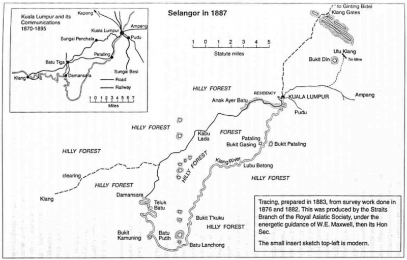
Peta Lembah Klang sekitar 1883-1887. Kelihatan Bukit Dinding di sebelah timur laut berhampiran Klang Gates, ditandakan sebagai “Bukit Din” (J.M. Gullick, 1998: "A History of Selangor 1766-1939", m.s. 85).
1883-10-19: Pembinaan Jambatan di Setapak
Arkib Negara 1957/0002580W, 19/10/1883: |"SETAPAK CART BRIDGE: INFORMATION FROM MR. RATHBORNE AS A CONTRACTOR PERTAINING TO THE CONSTRUCTION OF A NEW PATH AND FACILITY WHICH INCLUDES THE DETAILS SPECIFICATION OF WOOD AS MATERIALS AND COST FOR THE WORK.".
1884-04-12: Batu Tapak
Terdapat pendapat mengatakan asal usul nama Setapak ialah perlantikan “Batu Tapak” sebagai ketua kampung orang asli di situ pada 12 April 1884. Fakta ini (atau sekurang-kurangnya tarikhnya) mungkin tidak tepat, kerana terdapat rekod-rekod lebih awal yang telah pun menggunakan nama Setapak, seperti yang ditunjukkan sebelum ini.
“Setapak merupakan sebuah sub-bandar utama di Kuala Lumpur, Malaysia. Setapak terletak di bahagian timur laut Kuala Lumpur dan meliputi kawasan seluas 160 km2. Sempadan utara Setapak ialah Gunung Bunga Buah; sempadan timur lautnya ialah Gunung Bidai; ke arah timur ialah Bukit Dinding dan ke arah tenggara ialah Padang Tembak. 'Setapak' dinamakan sedemikian barangkali kerana lokasinya yang amat dekat dengan Kuala Lumpur. Terdapat juga pendapat yang mengatakan bahawa asal usul nama kawasan ini boleh dijelaskan berdasarkan sejarahnya. Menurut pendapat ini, penduduk Setapak terawal ialah orang asli dan orang Minangkabau dan pada 12 April 1884, Residen Selangor Frank Swettenham merayu supaya Batu Tapak dilantik semula sebagai ketua kampung bagi komuniti orang asli yang tinggal di kawasan tersebut. Oleh itu, nama Setapak diberi, sebagai penghormatan bagi ketua kampung tersebut.” (heritagemalaysia.my: |SETAPAK, KUALA LUMPUR").
“According to Savills Malaysia Sdn Bhd managing director Datuk Paul Khong, Setapak was once a tin mining and rubber plantation area that was inhabited by the Orang Asli and the Minangkabau people from West Sumatra. On April 12, 1884, Selangor’s British resident Frank Swettenham appealed for the reappointment of Batu Tapak as headman of the Orang Asli community in the area, and Setapak was named after him. “The name ‘Setapak’ means ‘one step’ in Malay. It is a 20-minute drive from the Kuala Lumpur city centre and is one of the oldest neighbourhoods in Gombak,” says Khong.” (Chung Ying Yi / The Edge Malaysia, 01 Nov 2021: |"Cover Story: Upcoming MRT Line 3 to enhance connectivity in Setapak").
1888-1894: Pembukaan Ladang-Ladang Kopi
Suatu Ringkasan
“The first coffee estate was opened on Weld's Hill (named after the then Governor) where Liberian coffee was planted by T. Heslop Hill, who was a partner in the well known firm of Hill & Rathborne, Contractors etc. This firm planted the Ginting Bedai and Batu Caves estates with Arabian Coffee, but later abandoned them owing to difficulties, over labour and the distance from Kuala Lumpur. Javanese and Pahang Malays planted their kampongs with Liberian between the race course and “Lincoln” Estate. Messrs Toynbee, Laird, Currie, and Dougal opened “Hawthornden”; L. Dougal “Edinburgh” at Kepong, also “Roslin” and “Lincoln” in the Setapah Valley. Later the Meikle brothers (“Lairds”) opened “Wardieburn”, and the Glassford brothers, who had planted coffee before in South India, “The Mount” E. V. Carey opened “New Amherst”, A. B. Lake and Paget “Kent”, and Murray Campbell “Aberseross” and all were planted with Liberian Coffee. About two thousand acres in all were then under cultivation on these properties, but about four times that amount of land had been taken up for future development.” (Rimba @ C. Grenier, 1922: |"Bygone Selangor; a souvenir").
Latar Perladangan: Sejarah Awal Perladangan Kopi di Kuala Lumpur
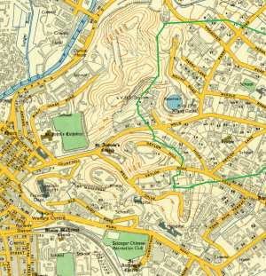
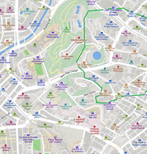
1882: Pembukaan Weld's Hill Estate di selatan Kuala Lumpur: “Coffee planting in the Straits Settlements may be said to date from the arrival of the first Ceylon planters in the Colony, who, on the failure of the industry in Ceylon, came over and settled chiefly in Johore and Singapore. The results of those early ventures induced Mr. T.H. Hill, one of the first and most enterprising of the Ceylon planters, to prospect the other Native States with a view to planting operations, the Government granting him large concessions of land in Sungei Ujong, Selangor and Perak as a Pioneer Planter, a title which he well deserves, having been the first to successfully cultivate Liberian coffee in these three States. In 1882 Mr. Hill, then managing the Ampang Tin Mines, selected and took up some land near Kuala Lumpur which he planted up with Liberian coffee, pepper, tea and other tropical trees. Mr. Evans, who died some years after cholera in Perak, was the first Superintendent on this the first coffee estate in Selangor, which was appropriately named “Weld's Hill”, after the late Sir Frederick Weld, then Governor of the Straits Settlements. This estate is now almost entirely under Liberian coffee, there being only a few acres of pepper left, which is being gradually worked out, as the proprietors evidently find coffee at $35 a pikul pays very much better than pepper at $10.” (F. A. Toynbee @ The Selangor Journal: Jottings Past and Present, Volume 1, No. 15, 7 April 1893: |"COFFEE"; The Singapore Free Press and Mercantile Advertiser (1884-1942), 13 April 1893, Page 2: |"COFFEE IN THE STRAITS").
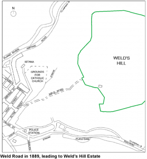
Kiri: Peta lokasi Weld's Hill Estate, 1889 (Mariana Isa, Maganjeet Kaur, 2015: "Kuala Lumpur Street Names: A Guide to Their Meanings and Histories", m.s.280).
Tengah: Peta lokasi bekas Weld's Hill Estate, 1957 (Surveyor General, Malaya @ The Australian National University, 1957: |"Malaysia, Malaya, Kuala Lumpur, 1957, 1:380 160").
Kanan: Peta lokasi bekas Weld's Hill Estate, kini (Mapcarta).
1882: Batu Caves Estate
“Messrs. Hill and Rathborne next selected and planted “Ginting Bedai” and “Batu Caves” Estates. Ginting Bedai, situated above the pass of that name on the main mountain range, at an elevation of between two and three thousand feet, was planted with coffee (Arabica), but had to be quite abandoned before any results could be obtained, as it was found impossible in the absence of roads to maintain a labour force some 23 miles from Kuala Lumpur in the heart of the jungle. Some trees that were then planted may even now be seen struggling for life amongst the native jungle. Batu Caves Estate is a stretch of some 2,850 acres of flat land lying round the base of the Batu Caves, from which it takes its name. At first there were only some 12 acres of coffee (Liberian) planted and a few trees of cocoa, but within the last three years the proprietors have considerably increased their planting operations.” (F. A. Toynbee @ The Selangor Journal: Jottings Past and Present, Volume 1, No. 15, 7 April 1893: |"COFFEE"; The Singapore Free Press and Mercantile Advertiser (1884-1942), 13 April 1893, Page 2: |"COFFEE IN THE STRAITS").
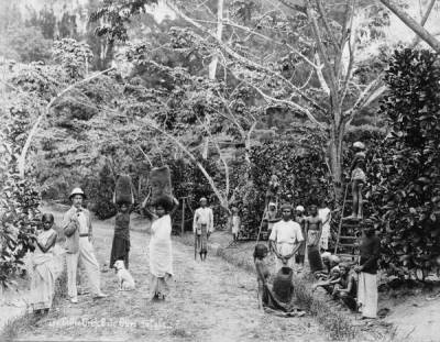
Ladang kopi di Batu Caves Estate, Selangor, tahun 1899 (RBG KEW, 12th February 2015: |"Coffee harvest at Batu Cave Estate, Singapore, 1899").
1884-1889: Ladang Orang Jawa dan Melayu Kuantan
“From 1884 to 1889 no new estates were opened, but a few Javanese and Kuantan Malays settled in different parts of the State and planted up an acre or two round their houses, the most extensive of these perhaps being the group lying between the Racecourse and Lincoln Estate.” (F. A. Toynbee @ The Selangor Journal: Jottings Past and Present, Volume 1, No. 15, 7 April 1893: |"COFFEE"; The Singapore Free Press and Mercantile Advertiser (1884-1942), 13 April 1893, Page 2: |"COFFEE IN THE STRAITS").
1887-1892: Pembinaan Tali Ayer oleh Penghulu Setapak
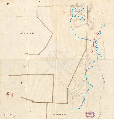
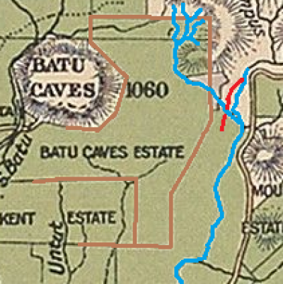
Kiri: Lakaran peta tali air yang dibina oleh Penghulu Setapak pada tahun 1896
Kanan: Lakaran yang sama berdasarkan peta tahun 1904
Pada tahun 1887, Penghulu Setapak, Khatib Koyan, telah mula membina tali air di sekitar tebing barat Sungai Gombak, berdekatan Batu Caves. Usaha ini terbengkalai kerana tidak cukup dana, kemudian disambung semula pada tahun 1890. Namun ia terpaksa dihentikan pada tahun 1892, apabila didapati tanah yang diairi oleh tali air itu telah terjual, berikutan kesilapan pihak juruukur kerajaan: “Land Office, Kwala Lumpur. Dated 9th June 1896. Subject: Tali Ayer, Setapak Mukim - Submit that it be taken over from Khatib Koyan by proprietor of Lease 815 or the $300 be expended over if be refunded to him. Sir, I have the honour to recommend the Penghulu of Setapak, Khatib Koyan for consideration in connection with a tali ayer constructed by him some years ago. I enclose two departmental papers bearing the same number which explain the circumstances under which the work was done. In about 1887 he expended about $300 and then stopped work for want of funds. In 1890 with the approval if not at the instigation of Government he expended $400 more advanced by Government on the same tali ayers. The work was approved as may be seen by the Resident and carried out under the inspection of the Settlement officer, Mr. Mellford. On taking over Settlement work in 1892 I was obliged to stop further Settlement in the neighbourhood, as stated on your Survey 2640/94. The agent of the proprietor of Lease 815 referred to in that paper refused to surrender more of the land therein contained than had actualy been given out on the completion of the survey (vide your Survey 5979/95) it was found that the land intended to be irrigated by this tali ayer was entirely included in the lease referred to. The error entirely attributable to deficiency of the former Survey of lease 815. Khatib Koyan has asked that his case may be represented and I trust that unless the proprietor of lease 815 is prepared to take over the tali ayer from him, the Government will see its way to refunding to him the $300 spent in 1890. I have the honour to be, Sir, Your Obedient Servant, J.H.M. Robson, as Collector of Land Revenue, K. Lumpur. *This letter was drafted by Mr. Ebden.?”
(Sumber: Arkib Negara 1957/0063517W, 07/04/1896: |"TALI AYER, SETAPAK MUKIM CONSTRUCTED BY PENGHULU KHATIB KOYAN").
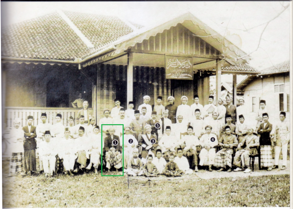

Khatib Koyan, 1910-an (dalam petak hijau): “A group portrait taken in the 1910s, in front of the Sulaiman Club, Kampung Baru, featuring the Minangkabau leaders of Kuala Lumpur: 1 Datuk Khatib Koyan ….. The signboard on the porch suggests that the Sulaiman Club doubled as the premises of the Madrasah Al-Sharafiah. COURTESY OF HAJI SHAHRIL KAMIL. ….. The Sulaiman Club, established in 1909, served as a recreational club for the Kampung Baru community, and also a rendezvous spot for the Sumatrans from Kuala Lumpur and Gombak.” (Abdur-Razzaq Lubis, 2018: "Sutan Puasa, Founder of Kuala Lumpur", m.s. 487).
1888-10: Ladang Ulu Gonggang (Hawthornden, Roslin, dan Lincoln Estate)
”Towards the end of 1888 the late Mr. William Dougal, Manager of the Chartered Bank in Singapore, Mr. Sword of the Straits Trading Company, Mr. Currie of the Borneo Company and myself (F.A. Toynbee) obtained a grant of 1,500 acres of land in the Setapak valley, in three blocks of 500 acres each, named, respectively, “Hawthornden”, “Roslin” and “Lincoln” after those places at home.” (F. A. Toynbee @ The Selangor Journal: Jottings Past and Present, Volume 1, No. 15, 7 April 1893: |"COFFEE"; The Singapore Free Press and Mercantile Advertiser (1884-1942), 13 April 1893, Page 2: |"COFFEE IN THE STRAITS").
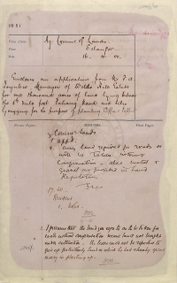
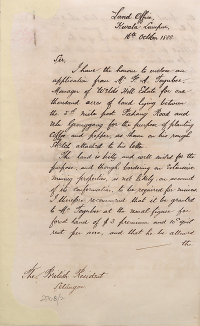
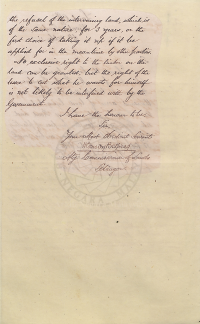
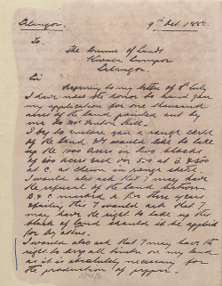
Pada Oktober 1888, Ladang “Ulu Gonggang” di Batu 5 Jalan Pahang Kuala Lumpur (di penghujung sebelah utara pusat perlombongan Gonggang) telah dibuka oleh F. A. Toynbee, bekas pengurus ladang Weld's Hill kepunyaan syarikat Messrs. Hill and Rathborne: “I have the honour to enclose an application from Mr. F. A. Toynbee, Manager of Weld's Hill Estate for one thousand acres of land lying between the 5th mile post Pahang Road and Ulu G®onggang for the purpose of planting coffee and pepper, as shown on his rough sketch attached to his letter. The land is hilly and well suited for the purpose, and though bordering on extensive mining properties, is not likely, on account of its conformation, to be required for mines. I therefore recommend that it be granted to Mr. Toynbee at the usual figure for forest land of $3 premium and 10c quit rent per acre, and that he be allowed the refusal of the intervening land, which is of the same nature, for 3 years, or the first choice of taking it up if it be applied for in the meantime by other parties. No exclusive right to the timber on the land can be granted, but the right of the lessee to cut what he wants for himself is not likely to be interfered with by the Government.” (Henry Conway Belfield @ PEJABAT SETIAUSAHA KERAJAAN NEGERI SELANGOR, 09/10/1888: |"ENCLOSES AN APPLICATIONS FROM MR.F.A.TOYNBEE MANAGER OF WELDS HILLS ESTATE FOR ONE THOUSAND ACRES OF LAND LYING BETWEEN THE 5TH MILE POST PAHANG ROAD AND ULU GONGGANG FOR THE PURPOSE OF PLANTING COFFEE & PEPPER").
Kemungkinan ladang Ulu Gonggang ini berkembang ke Batu 6 Jalan Pahang, dan dinamakan sebagai Ladang Hawthornden. Ladang ini kemudiannya berkembang ke timur/tenggara sehingga merangkumi sebahagian besar kawasan Bukit Dinding: “The opening of the Hawthornden Estate on the Pahang Road (6th mile) has given an impetus to planting enterprise in this direction. A second private planting company has taken up a thousand acres in this direction and commenced work already. Mr. Toynbee, late manager for Messrs. Hill and Rathborne, has done a great deal towards proving the success of planting enterprise in this state and it is to be hoped that the private enterprise on which he is now embarking will bring him the success he deserves.” (The Singapore Free Press and Mercantile Advertiser (Weekly), 5 July 1889, Page 15: |"SELANGOR NEWS").
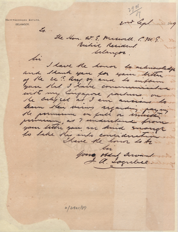
“To: The Hon. W. E. (William Edward) Maxwell. ? British Resident, Selangor. Sir, I have the honor to acknowledge and thank you for your letter of the 24th August 89 and to inform you that I have communicated with my Singapore partners on the subject as I am anxious to learn their views regarding paying the premium in full or remitting(?) premium, as I understand from your letter you are kind enough to take this into consideration. I have the honor to be, Sir, Your obedient servant, F. A. Toynbee.” (PEJABAT SETIAUSAHA KERAJAAN NEGERI SELANGOR, 02/09/1889: |"ACKNOWLEDGES LETTER OF 24TH AUGUST '89 RE REMISSION OF PREMIUMS ON CONCESSIONS").
MAKLUMAT LANJUT: Hawthornden Estate (1888-1983)
1889: Wardieburn dan Batu Estate
“This was immediately followed by the opening of “Wardieburn” by Messrs. C. and R. Meikle in 1889. This estate is thoroughly Scottish, as its name would lead one to expect. Named after the proprietor's beautiful home near Edinburgh, it is kept in high state of cultivation for which Scottish farmers are everywhere famed, and the good old Scottish title of “Laird” has been bestowed by his brother planters on one of the proprietors. At the end of 1889 Mr. H. Huttenbach acquired two small patches of coffee near Kuala Lumpur, one of some 10 acres, about half a mile out of town from Mr. Bristowe, late of the Land Office, which he has called “Selangor Coffee Garden,” the other, some three miles along the Selangor Railway, from some Javanese, which he named “Batu” Estate; both these properties he has, with his usual enterprise, very much improved and extended.” (F. A. Toynbee @ The Selangor Journal: Jottings Past and Present, Volume 1, No. 15, 7 April 1893: |"COFFEE"; The Singapore Free Press and Mercantile Advertiser (1884-1942), 13 April 1893, Page 2: |"COFFEE IN THE STRAITS").
1890: The Mount, Klang Gates, dan Aberscross Estate
“Towards the end of 1890 another estate was opened in the Setapak Valley by the Messrs. Glassford, who had had some experience of coffee planting in Southern India, and they named their estate “The Mount,” after a property of that name in Fifeshire. A few months later Mr. M.A. Stonor opened “Klang Gates” Estate, situated near the rocky gorge through which the waters of the Sungei Klang flow. About this time Mr. G. Murray Campbell, of Messrs. Campbell and Co., at that time engaged on the Railway Extensions in this State, applied for land from Government, and finally selected a block to the east of Lincoln Estate, but which was not opened until some months later. This was named “Aberscross” Estate, after the place where Mr. Campbell first saw the light and where his forefathers lived before the history of Scotland began. This estate has been largely extended since the first opening.” (F. A. Toynbee @ The Selangor Journal: Jottings Past and Present, Volume 1, No. 15, 7 April 1893: |"COFFEE"; The Singapore Free Press and Mercantile Advertiser (1884-1942), 13 April 1893, Page 2: |"COFFEE IN THE STRAITS").
1892-06-21: Surat permohonan: “Land Office, Kuala Lumpur, 21st June 1892. … Sir, I have the honor to forward herewith a copy of a letter received from Messrs: C and J Gordon Glassford respecting their Coffee Estate in Setapak mukim and to ask authority to issue to them a permit under schedule C to be re: placed by a Grant on Survey. 2. They have asked that their land shall have a frontage on the new Bentong Road. As this was refused to Mr. Carey it cannot be granted to Messrs. Glassford who should however be allowed an approach from it. A sketch showing the shape and position of the land originally applied by them will be found in Lands 1304/92. I have the honor to be, Sir, Your most obedient Servant, ?, Collector of Land Revenue, Selangor.” Maklumbalas: “Govt. Sec S: Permit was prepared but Mr Glassford's Estate is now being surveyed. Permit therefore is unnecessary. YVE/7.9.” (Arkib Negara 1957/0032637W: |"FORWARDS COPY OF A LETTER FROM MESSRS; C&J GORDON GLASSFORD RESPECTING THEIR COFFEE ESTATE IN SETAPAK MUKIM AND ASKS AUTHORITY TO ISSUE TO THEM A PERMIT UNDER SCHEDULE C: INFORMATION FROM COLLECTOR LAND REVENUE TO THE GOVERNMENT SECRETARY REGARDING THE COMMAND TO GRANT A PERMIT TO C AND J GORDON GLASSFORD, CONTRACTOR FOR THEIR COFFEE ESTATE WHICH IS LOCATED AT SETAPAK AND THE OUTLINE SHOWS THE SHAPE AND POSITION OF THE LAND.").
1892: New Amherst dan Kent Estate
“The next block taken up was by Mr. E.V. Carey, acting on behalf of some influential Ceylon gentlemen and himself, early in 1892. The land selected was in the Gombak Valley, opening out of the Setapak Valley, and amounted to 1,000 acres, to which he gave the name of “New Amherst”, after his old Ceylon estate. The last estate opened in Selangor, “Kent”, the property of Mr. A.B. Lake, is on the Batu Road, and originally this land formed part of Messrs, Hill and Rathborne's concession at Batu Caves.” (F. A. Toynbee @ The Selangor Journal: Jottings Past and Present, Volume 1, No. 15, 7 April 1893: |"COFFEE"; The Singapore Free Press and Mercantile Advertiser (1884-1942), 13 April 1893, Page 2: |"COFFEE IN THE STRAITS").
1892-04-09: Aduan F.A. Toynbee terhadap Penghulu Setapak yang menghalang pekerjanya menebang pokok di ladang New Amherst untuk tujuan pembinaan banglo di situ: “New Amherst Estate, Setapak Valley, Kwala Lumpor, Selangor, 9th April 1892. To: The Government Secretary, Kwala Lumpor. Sir, I have the honor to inform you that the Punulu (sic: Penghulu) of Setapak has stopped a number of my Chinese tukans (sic: tukangs) cutting plants upon the New Amherst Estate propery for the New Amherst Estate Bungalow, on the grounds that they have no Government Pass. As none of the wood is being cut on any but the Estate property & none being used except for the Estate buildings I can't understand what grounds the Punulu (sic: Penghulu) has to stop my works & as the work in question (the bungalow) is one of the greatest importance to me I would ask you to kindly instruct the Punulu (sic: Penghulu) of Setapak to instruct the tukans (sic: tukangs) to return to their work. I have the honor to be, Sir, Your obedient servant, F.A. Toynbee, Superintendent.” Maklumbalas: penghulu tidak tahu mengenai ladang baru tersebut, dan F.A. Toynbee diminta menandakannya dengan jelas: “Govt Sec S, The Penghulu was unaware of the boundaries of Amherst Estate and understood from the Chinese cutters that they were cutting wood for Mr Toynbee. He assumed that it was for use on Hawthornden and stopped them accordingly. 2. Mr Toynbee's demarcation of the Estate having been accepted he must indicate it by proper marker to the satisfaction of the chief surveyor as stipulated in the permit. - ?, 13.4” (Arkib Negara 1957/0031277W, 09/04/1892: |"RE HIS CHINESE TUKANS BEING STOPPED BY THE PENGHULU OF SETAPAK FROM CUTTING PLANTS ON THE NEW AMHERST ESTATE RE.").
1892-03-01: Cadangan Kawalan Tanaman Tanah Adat
“Settlement Officer, Kuala Lumpur. 1.3.92. … 1. Herewith a list of customary land holders about whom I spoke to the Resident a few days since. 2. These people with the exception of three held formerly agreements for lease paying a quit rent of 50/00. 3. When I assessed the land I was doubtful as to how fairly to deal with them. 4. They all cultivated nothing but coffee. Thinking at the time I assessed this land, that an ad valorem export duty was to be imposed upon coffee I thought it fair to charge these people in the same manner as coffee planters on large areas. 5. I did the same in regard to three others who applied for new lands for coffee planting. 6. Since issuing these titles I have come to the conclusion that the principle is wrong especially in assessing lands newly applied for for coffee planting. 7. I would now suggest that my assessment with regard to those who have taken extracts in exchange for agreements be allowed to stand, but that it be not made a precedent in future cases. 8. With regard to land applied for by Malays for coffee planting I would suggest a fixed rate with an endorsement on the extract and in the remarks column of the register as stating that the land is for coffee cultivation only that if other crops are? grown the assessment may be raised at any time. If this is not done every applicant will say this land is for coffee and mix up a little coffee with the other produce. 9. Will you forward this for the Resident's consideration, so as to get the matter settled without delay. ?, 1.3.92” (Arkib Negara 1957/0030389W, 01/03/1892: |"RE ASSESSMENT OF COFFEE LAND HELD UNDER CUSTOMARY TITLE IN THE MUKIM OF SETAPAK: SUBMISSION BY THE COLLECTOR OF LAND REVENUE TO THE GOVERNMENT SECRETARY OF AN INFORMATION FROM SETTLEMENT OFFICER WHO CARRIES OUT THE ASSESSMENT WORK ON THE PLANTATION LAND IN SETAPAK AND REQUESTS FOR GOVERNMENT'S APPROVAL ON THE SUGGESTION TO FIX A RATE CHARGED ON THE MALAY APPLICANT.").
1893: Keadaan Perladangan
“The steady increase in the number of coffee estates argues well for the future of Selangor as a coffee-producing country. The estates in the Kuala Lumpur District alone now represent an area of some 7,000 acres of which over 1,500 acres are planted with Liberian coffee.” (F. A. Toynbee @ The Selangor Journal: Jottings Past and Present, Volume 1, No. 15, 7 April 1893: |"COFFEE"; The Singapore Free Press and Mercantile Advertiser (1884-1942), 13 April 1893, Page 2: |"COFFEE IN THE STRAITS").
1893-05-21: Permohonan Ladang Ditolak
“Land Office (?), Kuala Lumpur. 21st May 1893. Sir, I am directed to acknowledge receipt of your communication of the 19th instant addressed to the Resident and to inform you that the application therein cannot be entertained as a portion of the land applied for falls within the present estate of Amherst and an application by Messrs. C and J Gordon for 200 acres to the north of portions in Setapak Mukim has to receive attention when Amherst Estate has been surveyed. I have the honour to be, Sir, Your obedient servant, ?, Government Secretary, Selangor. F.A. Toynbee ?, Lincoln Estate, K. Lumpur.” (Arkib Negara 1957/0043388W, 21/05/1893: |"MR. F. A. JOYNBEE - APPLIES ON BEHALF OF MESSRS. PAGE & CO. FOR A BLOCK OF 500 ACRES OF LAND IN THE SETAPAK VALLEY, FOR THE PURPOSE OF PLANTING LIBERIAN COFFEE").
1894: Statistik Perladangan
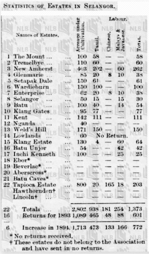
Statistik sebahagian ladang-ladang di Selangor, 1894 (Pinang Gazette and Straits Chronicle, 26 February 1895, Page 3: |"Statistics of Estates in Selangor").
1892-1894: Pembinaan Jalan Ampang-Ulu Klang
“The road from Ampang to Ulu Klang was let to Mr. W.D. Mitchell on contract and good progress made. The unsatisfactory contract, which was being still more unsatisfactorily carried out by Messrs. Becher, Louis and Co., for a trace and footpath through the Setapak Valley in the direction of Pahang, was ultimately determined. The bridle-path, of which the gradient is excellent, from Ginting Bidai to Kuala Tali was let to Mr. Edwin Watson and pushed on in a very satisfactor manner - the bridgework being very good.” (Pinang Gazette and Straits Chronicle, 14 July 1893, Page 3: |"THE SELANGOR REPORT FOR 1892").
1894-03-12: Tuntutan Pampasan Pemusnahan Tali Air Sawah Padi
“PETITION FROM PADDY PLANTERS IN THE MUKIM OF SETAPAK REGARDING THE CLAIM FOR COMPENSATION OWING TO THE DEMOLITION OF THEIR TALI AYERS (CANALS) IN THE NEIGHBOURHOOD OF THE NEW ULU GOMBAK ROAD IN 1894.” (Arkib Negara 1957/0048864W, 12/03/1894: |"RE DESTRUCTION OF TALI AYERS BELONGING TO PLANTERS IN SETAPAK MUKIM").
1894: Jalan Siap Dibina
“The Setapak Valley, the Ulu Klang, Roads, and the bridle road to Bentong were completed during the year.” (Pinang Gazette and Straits Chronicle, 12 June 1895, Page 2: |"ROAD CONSTRUCTION IN SELANGOR in 1894").
1895-02-25: Pembinaan Jalan Princes
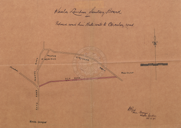
Pembinaan jalan menghubungkan balai polis Setapak (lama) dengan Circular Road. Bakal dinamakan “Princes Road”. Kini ia adalah Jalan Raja Muda Abdul Aziz: “Sanitary Board Office, Kuala Lumpur. 25 February 1895. Subject: Applying Permission to Commence New Road Work A.E.16.(?) Stapak to Circular Road. Sir, I have the honour to request the sanction of Government to Commence the Construction of the new road from Stapak Police Station to the Circular Road A.E.16.(?). 2. A tracing showing the proposed new road is attached. I have the honor to be, Sir, Your Obedient Servant, ?, Chairman.” (Arkib Negara 1957/0055212W, 25/02/1895: |"SETAPAK - CIRCULAR ROAD' SANCTION FOR THE CONSTRUCTION OF;").
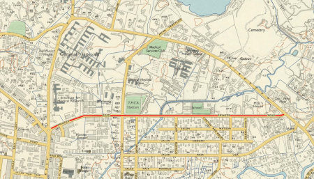
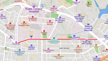
Kiri: Peta Princes Road, 1957 (Surveyor General, Malaya @ The Australian National University, 1957: |"Malaysia, Malaya, Kuala Lumpur, 1957, 1:380 160").
Kanan: Peta Jalan Raja Muda Abdul Aziz, kini (Mapcarta).
1897-1904: Perlombongan Pesat
Setakat Januari 1897, kawasan Gonggang masih kawasan perlombongan bijih timah, sebagaimana dalam liputan peralihan pengurusan salah sebuah lombong di situ: “Chye Ah Chung, a Mines Orderly in the time of Mr. Hill, who returned to China some time ago, was succeeded, says the Malay Mail, in office by his brother Ah Fong. Between them the brothers held the post to the end of last year. It has since become known that they had all the time been running a mine at Gonggang. Ah Fong is noe keeping a shop at Gonggang while Ah Chung has made away with the “biji.” To make matters worse there is a sum of about $2,000 owing to coolies as wages, and Ah Chung has gone away.” (Pinang gazette and Straits chronicle, 26 January 1897, Page 2: |"LOCAL AND GENERAL.").
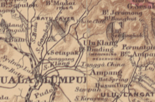
Peta sekitar Gonggang, berdasarkan peta Semenanjung Tanah Melayu tahun 1898. Kelihatan kawasan perlombongan Gonggang ada ditandakan (Edward Stanford @ Royal Asiatic Society of Great Britain and Ireland, Straits Branch, 1898: "A map of the Malay Peninsula / compiled by and published for the Straits Branch of the Royal Asiatic Society, Singapore ; prepared and drawn by John van Cuylenburg, Singapore").
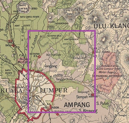

Peta Gonggang (kanan) dan kawasan sekitarnya (kiri), berdasarkan peta negeri Selangor, tahun 1900-an (Edinburgh Geographical Institute, 1904 @ Yale University Library - Digital Collections: |"Selangor, Federated Malay States, 1904 / John Bartholomew & Co ; W.T. Wood, chief draftman").
Di dalam peta tahun 1904 ini, kelihatan kawasan “Gonggang” (ditandakan merah) di lembangan Sungai Bunus (ditandakan biru) masih menjadi pusat perlombongan bijih timah. Demikian juga di sepanjang lembangan Sungai Klang di sebelah timurnya. Turut kelihatan, ladang-ladang kopi yang dibuka secara besar-besaran sejak 1880-an, seperti Batu Caves di sebelah barat laut, dan Ladang Hawthornden di sebelah timur laut. Ladang yang ditandakan dengan sempadan hijau bakal menjadi/dinamakan Gonggang Estate.
MAKLUMAT LANJUT: Gonggang Estate (?-1983)
1902-02-12: Keadaan Perlombongan di Gonggang Utara
Surat pejabat tanah kepada pejabat Residen, memohon kelulusan beberapa cadangan. Daripada isi surat ini, dapat dilihat secebis suasana perlombongan, khususnya di Gonggang Utara yang bersempadan dengan Wardieburn (blok Setapak Dale) dan Hawthornden Estate. Terdapat campuran tanah pertanian dan perlombongan di situ: “Land Office, Kuala Lumpur, 1st: November, 1901. Exchange of Titles by Entry No: 2o36 in Setapak Mukim Register for Mining Titles. Recommends approval of:- Sir, I have the honour to recommend that the State Council approve of the exchange of the Titles by Entry in the Mukim register for mining titles for the nine portions of land shewn in pink on attached tracing which are more particularly described in schedule A attached. 2. Schedule B shews what premium has been paid for mining land adjacent the portions mentioned being shewn in blue on tracing and reference in the schedule being made in some instances to your papers. 3. Document C attached is a copy of a report from Assistant Collector of Land Revenue on all the portions except 871 held under Serial 2036. I do not agree with the Assistant Collector of Land Revenue's value of this land for mining i.e. $10. per acre, I recommend that the State Council charge $15 per acre which is the amount lately charged for similar concessions in the neighbourhood. 4. Document D is a copy of Assistant Collector of Land Revenue's report on the portion 871. The purchase of this land gave $35 per acre for it with the evident intention of asking for permission to mine it and thereby fixing its value to him as mining land but in a recent case when I pointed out that Towkeh Loke Yew had in the same way fixed the value of a portion at $100 per acre for mining, the State Council allowed him to have mining rights for $25 per acre, I therefore recommend that the owner of this portion pay $25 per acre. This portion is within the 4 mile radius from Kuala Lumpur within which area the Resident (Mr: Belfield) would not allow mining close to the road than one hundred yards from the centre without his special authority, I therefore recommend that as this portion is very close to the 4 mile limit and it is within my knowledge that the land close up to the road is the more valuable - that it be authorised for mining up to within 50 yards not 50 feet as recommended by the Assistant Collector of Land Revenue. I have the honour to be, Sir, Your Obedient Servant, ?, Collector of Land Revenue, Kuala Lumpur.”
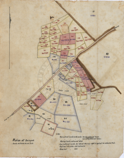
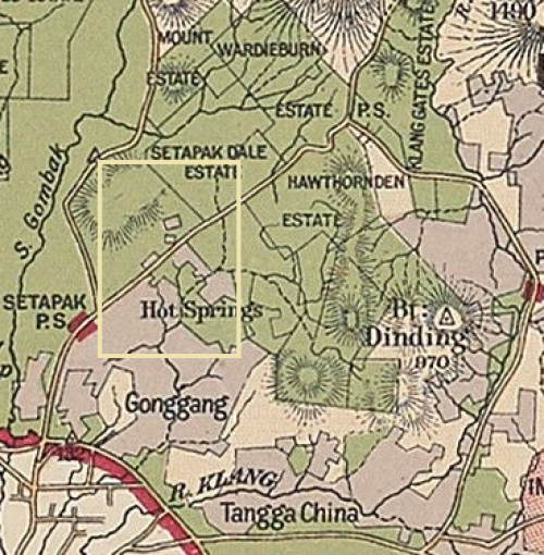
Kiri: Lakaran yang dirujuk di dalam surat di atas.
Kanan: Lokasi lakaran menurut peta tahun 1904, ditandakan sebagai petak kuning (Berdasarkan peta Edinburgh Geographical Institute, 1904 @ Yale University Library - Digital Collections: |"Selangor, Federated Malay States, 1904 / John Bartholomew & Co ; W.T. Wood, chief draftman").
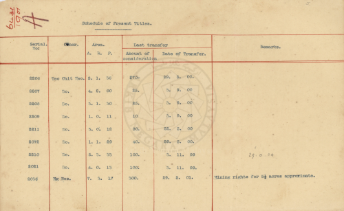
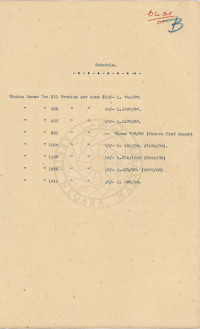
Kiri: Schedule A yang dirujuk peta dan surat di atas.
Tengah: Schedule B: “Schedule B shews what premium has been paid for mining land adjacent the portions mentioned being shewn in blue on tracing and reference in the schedule being made in some instances to your papers.”
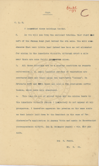
Kanan: Dokumen C: “Document C attached is a copy of a report from Assistant Collector of Land Revenue on all the portions except 871 held under Serial 2036.”
Butiran Dokumen C: “Document C: C.L.R. I Inspected these holdings to-day. 2. As you will see from the enclosed tracing, the right and left of the Pahang Road just beyond the 4th mile. You will also observe that very little land indeed has been as yet alienated for mining in the immediate vicinity, although about a mile away there are some fairly prosperous mines. 3. All these holdings are in a similar condition as regards cultivation i.e. small isolated patches of vegetables are scattered here and there among the inevitable “lalang”. On Extracts 2072 and 2206 there are also a few over-grown coffee bushes, which have been abandoned. 4. This land is not of proved value and the mining lands in the immediate vicinity (which I inspected) do not appear at all prosperous. I therefore appraise the premium on the same scale as that lately laid down by the Resident in the case of Mr: Kindersley's application in Ampang Mukim and again in Secretariat correspondence 4189/01. (an U. Selangor paper) - viz. $10 per acre. Sd: E. Pratt. 26.9.01.”
Maklumbalas pejabat residen, diikuti jawapannya:-
“C.L.R. (Collector of Land Revenue), To whom do the blocks numbered 17, 41 and 133 belong? And are they under cultivation. 5.11.01. ?
S.R. (Secretary to Resident), Portion 17 is Wardieburn Estate Messrs Meikle. Portion 41 and 133 are Hawthornden Estate. 41 belongs to the Borneo Co and 133 15 Mr. G.D. Toynbee, both cultivated. 2. Mining is being carried on on both the(?) Estates. 21.11.01. ?”
(Sumber: Arkib Negara 1957/0099647W, 12/02/1902: |"EXCHANGE OF TITLES BY ENTRY NO. 2036 IN SETAPAK MUKIM REGISTER. RECOMMENDS APPROVAL OF: INFORMATION BY THE COLLECTOR OF LAND REVENUE TO THE SECRETARY TO RESIDENT REGARDING THE ACCEPTANCE OF THE ALIENATION FOR DRILLING GROUND AND ASKS FOR THE RESIDENT'S AUTHORITY TO GIVE A PERMIT.").
1907-01-21: Pewartaan Rifle Range
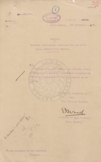
Kiri: Surat kelulusan pewartaan: “Land Office, Kuala Lumpur, 5th November, 1906. Subject: Forwards notification declaring the new Rifle Range a Reserve for Gazette. Sir, Refering to your 4882/03 and 3451/05, I have the honour to forward a Notification declaring the New Rifle Range a Reserve for publication in the Gazette. I have the honour to be, Sir, Your Obedient Servant, ?, Collector of Land Revenue, Kuala Lumpur.”
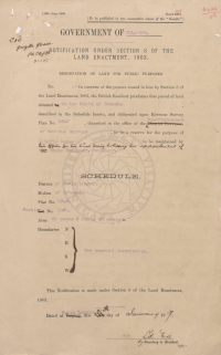
Kanan: Dokumen pewartaan: “In exercise of the powers vested in him by Section 8 of the Land Enactment, 1903, the British Resident proclaims that parcel of land situated in the Mukim of Setapak described in the Schedule hereto, and delineated upon Revenue Survey Plan No. 3949, deposited in the office of the Superintendent of Revenue Surveys, to be a reserve for the purpose of a Rifle Range to be maintained by his office for the time being holding his appointment of State Engineer, Selangor. SCHEDULE: District of Kuala Lumpur. Mukim of Setapak. Plan No. 3949. Portion No. 1363. Area 91 acres 0 roods 50 perches. … Dated at Kuala Lumpur, 21 day of January 1907. ? Ag. Secretary to Resident.”
(Sumber: Arkib Negara 1957/0132544W, 05/11/1906: |"RESERVATION OF LAND NEW RIFLE RANGE - SETAPAK - NOTIFICATION TO BE PUBLISHED IN THE GAZETTE").
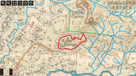
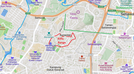
Kiri: Peta lokasi Rifle Range (ditanda merah), 1923. Mercu tanda: Sungai Bunus di sebelah barat. Sungai Peran (anak Sungai Bunus) di sebelah utara, merentasi Gonggang Estate di sebelah timur laut. Bulatan ungu berdekatan Sungai Peran, ditandakan sebagai “Chin. Cemy.” (Chinese Cemetery): Perkuburan Loke Yew. Sungai Klang di sebelah selatan. (berdasarkan peta Survey Department, Singapore, 1923: |"Selangor. Parts of K. Lumpur, Ulu Selangor, Klang & Ulu Langat Districts, Kuala Lumpur").
Kanan: Peta lokasi Rifle Range (ditanda merah, sebahagian kawasan Kementerian Pertahanan (KEMENTAH)), kini (Mapcarta).
Menurut laporan tahun 1924, Terdapat lombong lampan di sebelah timur Rifle Range, kemungkinan di sekitar anak-anak Sungai Klang yang ditandakan biru disebelah kanan Rifle Range di atas: “By E. S. Willbourn, Asst. Geologist, F.M.S. Kuala Lumpur … There are several open-cast mines in the alluvium near Setapak, most of the country between here and the granite to the east and to the Ampang road being formerly mined for tin, and at the present time there are lampan workings in the weathered schists just to the east of the rifle-range.” (Pinang Gazette and Straits Chronicle, 1 March 1924, Page 5: |"MINING IN SELANGOR").
1920-1930an: Keadaan Perlombongan dan Perladangan
Gonggang Estate
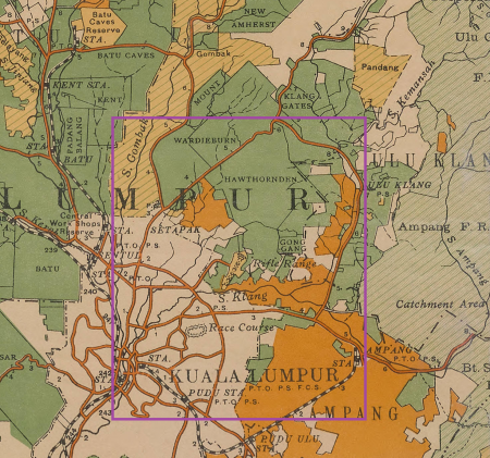
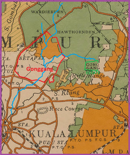
Peta Gonggang (kanan) dan kawasan sekitarnya (kiri), berdasarkan peta negeri Selangor, tahun 1926. Kelihatan kawasan "padang tembak" (Rifle Range) di sebelah Gonggang Estate (Malaya Survey Department, 1926 @ University of Minnesota Libraries: |"Selangor : Federated Malay States 1926").
MAKLUMAT LANJUT: Gonggang Estate (?-1983)
Kampung Gonggang
Sekitar waktu ini, terdapat beberapa peristiwa telah dilaporkan di akhbar-akhbar, melibatkan sebuah petempatan bernama “Kampung Gonggang”, yang terletak berhampiran dengan Rifle Range (kini kawasan Kementerian Pertahanan (KEMENTAH)). Mungkinkah kampung ini bakal menjadi sebahagian daripada Kampung Datuk Keramat kini?
“Jalan Datuk Keramat: This road lies within the village of Datuk Keramat, which was once part of Gonggang and Kampung Tangga Cina. The 170-acre area was declared a Malay Reserve in 1957. … Sources: Ani 2000 (Ani binti Ahmad (2000), Tanah Rizab Melayu di Wilayah Persekutuan Kuala Lumpur: Satu Kajian Kes terhadap Aspek Perumahan di Kampung Dato' Keramat, Kuala Lumpur: Universiti Malaya):141-145; Dewan Bahasa 1995 (Dewan Bahasa & Pustaka (1995), Ensiklopedia Sejarah dan Kebudayaan Melayu Jilid 2, Kuala Lumpur: Dewan Bahasa dan Pustaka): 1076” (Mariana Isa, Maganjeet Kaur, 2015: "Kuala Lumpur Street Names: A Guide to Their Meanings and Histories", m.s. 87).
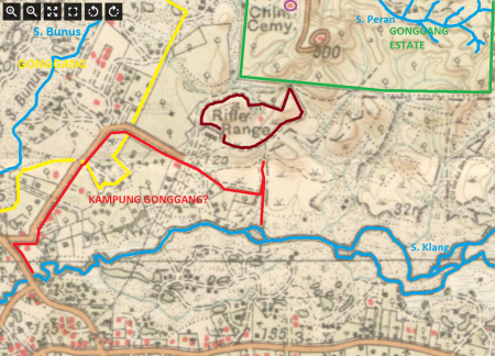
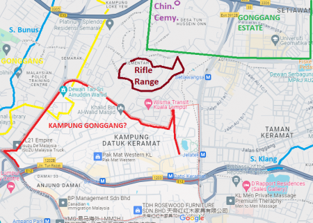
Kiri: Peta kemungkinan lokasi Kampung Gonggang secara kasar (perkampungan berhampiran Rifle Range), 1923 (berdasarkan peta Survey Department, Singapore, 1923. Mercu tanda: Sungai Bunus dan Gonggang di sebelah barat. Sungai Peran (anak Sungai Bunus) di sebelah utara, merentasi Gonggang Estate di sebelah timur laut. Bulatan ungu berdekatan Sungai Peran, ditandakan sebagai “Chin. Cemy.” (Chinese Cemetery): Perkuburan Loke Yew. Sungai Klang di sebelah selatan: |"Selangor. Parts of K. Lumpur, Ulu Selangor, Klang & Ulu Langat Districts, Kuala Lumpur").
Kanan: Peta kemungkinan lokasi Kampung Gonggang secara kasar, kini (berdasarkan Google Maps).
MAKLUMAT LANJUT: Kampung Gonggang.
Setapak Tin
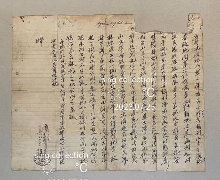
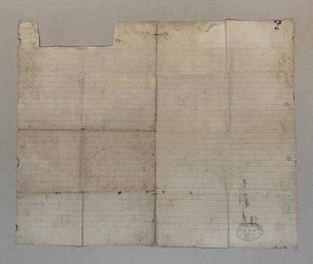
“1933 Malaya Kuala Lumpur Kwong Man Lee Setapak tin mine lease contract 廣萬利錫鑛公司” (dazhonghua / 大中華資料室 Great China Collectables @ eBay, 25 Julai 2023: |"1933 Malaya Kuala Lumpur Kwong Man Lee Setapak tin mine lease contract 廣萬利錫鑛公司").
1950-an: Perkembangan Perlombongan
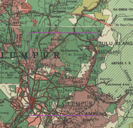
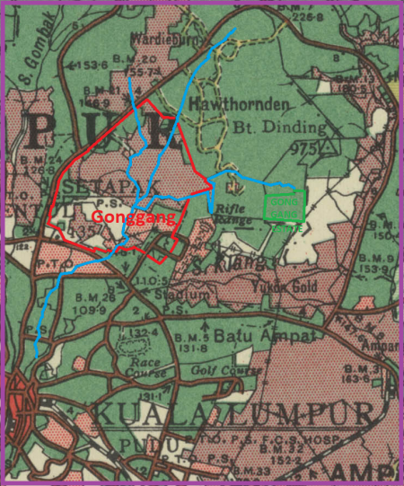 Peta Gonggang (kanan) dan kawasan sekitarnya (kiri), berdasarkan peta negeri Selangor, tahun 1950 (Surveyor General, Malaya, 1950 @ Australian National University. Perladangan telah berkembang, di samping perlombongan: |"Malaysia, Malaya, Selangor 1950, Land Use, South Sheet, 1950, 1:126 720"). Sedikit sebanyak kekal sebagaimana tahun 1920-an. Namun kawasan lombong kini telah berkembang ke utara Gonggang, iaitu bahagian hulu Sungai Bunus di dalam Wardieburn Estate.
1957: Pewartaan Kampung Datuk Keramat Sebagai Rizab Melayu
Kampung Datuk Keramat dahulunya sebahagian daripada kawasan perlombongan Gonggang dan Tangga Cina. Pada tahun 1957, ia secara rasminya menjadi kawasan rizab Melayu: “Jalan Datuk Keramat: This road lies within the village of Datuk Keramat, which was once part of Gonggang and Kampung Tangga Cina. The 170-acre area was declared a Malay Reserve in 1957. … Sources: Ani 2000 (Ani binti Ahmad (2000), Tanah Rizab Melayu di Wilayah Persekutuan Kuala Lumpur: Satu Kajian Kes terhadap Aspek Perumahan di Kampung Dato' Keramat, Kuala Lumpur: Universiti Malaya):141-145; Dewan Bahasa 1995 (Dewan Bahasa & Pustaka (1995), Ensiklopedia Sejarah dan Kebudayaan Melayu Jilid 2, Kuala Lumpur: Dewan Bahasa dan Pustaka): 1076” (Mariana Isa, Maganjeet Kaur, 2015: "Kuala Lumpur Street Names: A Guide to Their Meanings and Histories", m.s. 87).
1960-an: Bibit Awal Urbanisasi
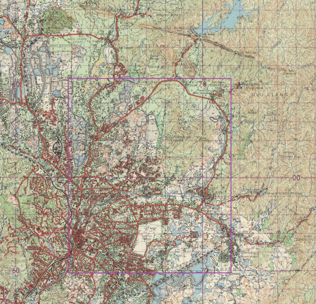
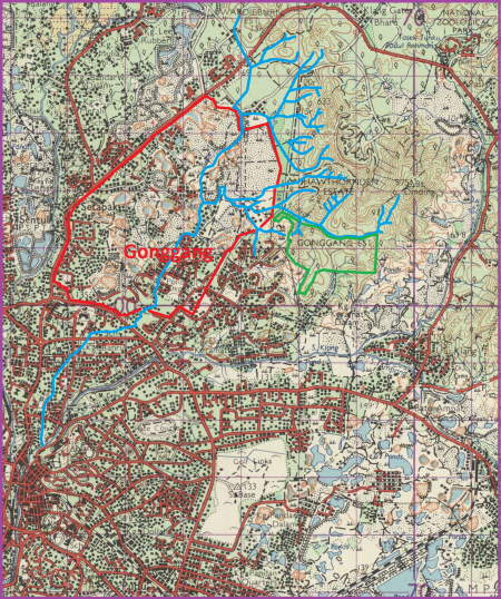
Peta Gonggang (kanan) dan kawasan sekitarnya (kiri), berdasarkan peta Director of National Mapping, Malaysia, 1962: |"Malaysia, Selangor, Kuala Lumpur, Series: L7010, Sheet 94, 1962, 1:63 360").
Pada 3 September 1965, kerajaan persekutuan telah mengumumkan perancangan sebuah perbandaran baru di Ladang Wardieburn, termasuk sebahagian kecil Ladang Hawthornden. Kemungkinan kawasan tersebut di sekitar Taman Bunga Raya kini. Ini adalah antara pembangunan terawal yang melibatkan kawasan ini: “Ladang Wardeiburn di-Jalan Ulu Klang menjadi sa-buah “Bandar Baru” yang paling moden sa-kali di-Ibukota ini manakala Kerajaan membena kira2 200 penchakar langit 17 tingkat yang mengandongi 42,000 rumah pangsa mulai awal tahun hadapan. … Projek tersebut yang dibahagikan kepada 11 kawasan berasingan akan meliputi seluroh kawasan ladang itu sa-luas 828 ekar termasuk sa-bahagian kechil dari kawasan Ladang Hawthornden.” (Berita Harian, 4 September 1965, Page 5: |"Bandar baru penchakar langit di-Ulu Klang").
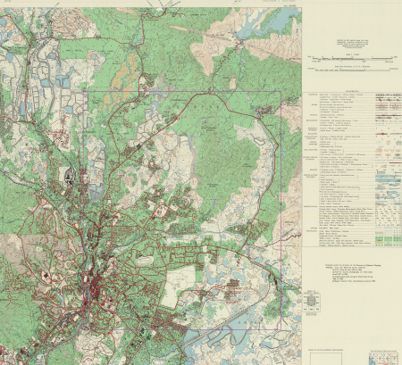
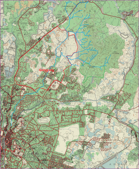
Peta Gonggang (kanan) dan kawasan sekitarnya (kiri), berdasarkan peta Malaysia : Director of National Mapping, 1967: |"Malaysia, Selangor, Kuala Lumpur, Series: L8010, Sheet 94k, 1967, 1:25 000").
Menurut Presiden Pertubuhan Suara Setiawangsa, Harun Mohd Amin, sehingga tahun 1960-an terdapat sebuah air terjun di situ, yang kini telah dikambus atau diubah alirannya mengikut binaan sistem perparitan baru: “Sementara itu, Presiden Pertubuhan Suara Setiawangsa, Harun Mohd Amin berkata, rancangan pembangunan di Bukit Dinding perlu dikaji sebaiknya kerana ia bukan sekadar bukit tetapi merupakan kawasan tadahan dan mempunyai laluan air. Harun juga mendakwa berdasarkan sejarah Bukit Dinding, dahulunya terdapat aliran air terjun namun telah ditutup.” (Hidayah Hairom @ Sinar Harian, 20 November 2014 @ Pusat Maklumat Malaysiana, Perpustakaan Negara Malaysia: "Bukit Dinding diancam bahaya").
1980-02-01: Setapak Tin Menjadi Taman Tasik Titiwangsa
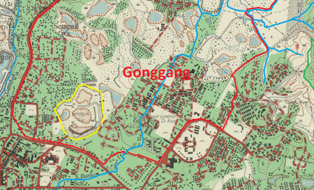
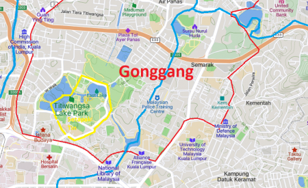
Kiri: Peta lokasi Setapak Tin, ditandakan kuning di dalam kawasan perlombongan Gonggang / lembah Sungai Bunus (sempadan merah), 1967.
Kanan: Peta lokasi Setapak Tin, ditandakan kuning, kini Taman Tasik Titiwangsa (Mapcarta).
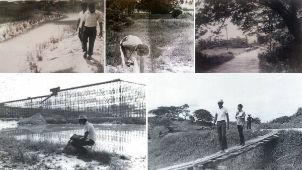
Setapak Tin, akhir 1960-an (Hassan Abd Muthalib @ Malaysian Heritage and History Club, 8 Oktober 2020: "What Taman Titiwangsa & the area behind Istana Budaya & the National Library used to look like in the late 1960s").
“Taman Tasik Titiwangsa mempunyai keluasan iaitu 46.13 hektar atau 114 ekar yang terletak 3 km dari pusat bandar dan dibuka dengan rasminya pada 1 Februari 1980 oleh Perdana Menteri Allahyarham Tun Hussein Onn, sebelumnya dinamakan Taman Jalan Kuantan. Nama Taman Tasik Titiwangsa dipilih memandangkan Titiwangsa adalah banjaran gunung yang menjadi tulang belakang Semenanjung Malaysia. Nama tersebut dirasakan sesuai kerana pemandangan tanah datar kawasan taman itu serta kehijauannya menggambarkan suasana pemandangan dan iklim banjaran gunung tersebut. Kerja-kerja membinanya telah bermula pada tahun 1975 dan akan dilengkapkan dengan berbagai kemudahan sukan seperti kolam renang, gelanggang tenis, rumah kelab, padang permainan dan lain-lain.” (Kementerian Wilayah Persekutuan, 13 Julai 2022: |"Taman Tasik Titiwangsa").
Teks ucapan Perdana Menteri, Tun Hussein Onn, ketika perasmian dan penamaan Taman Tasik Titiwangsa pada 1 Februari 1980, jam 9 pagi:-
1983: Pembangunan Ladang Hawthornden dan Gonggang
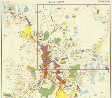
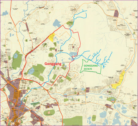
Peta Gonggang (kanan) dan kawasan sekitarnya (kiri), berdasarkan peta Malaysia, Jabatanarah Pemetaan Negara @ American Geographical Society Library, University of Wisconsin-Milwaukee Libraries, 1982: |"Kuala Lumpur / diterbitkan oleh Pengarah Pemetaan Negara". Ketika ini belum ada sebarang pembangunan di sebahagian besar Ladang Hawthornden, Gonggang Estate, dan Bukit Dinding.
Pada 9 Disember 1983, Pelan Induk bagi kawasan ini, dikenali sebagai Projek Pusat Pertumbuhan Bandar Baru Ladang Hawthornden, telah diluluskan. Sejak itu, kawasan Wangsa Maju dibangunkan, seksyen demi seksyen, iaitu Seksyen 1 (apartmen kos rendah), Seksyen 2 hingga 4 (apartmen kos sederhana), dan Seksyen 5 (rumah teres, apartmen dan kondominium). Di dalam pelan tersebut, sebahagian daripada Bukit Dinding (ditandakan sebagai “R-12”) telah pun diwartakan sebagai “Tapak Kediaman”, namun tidak dibangunkan, dan masih kekal sebagai kawasan hutan sehingga kini: “Sebelum tahun 1980, keseluruhan kawasan Wangsa Maju merupakan ladang getah yang dikenali sebagai Ladang Hawthornden. Pada tahun 1983, Pelan Induk untuk kawasan ini, dikenali sebagai Projek Pusat Pertumbuhan Bandar Baru Ladang Hawthornden, telah diluluskan, dan ditunjukkan di rajah Figure 3. Tapak Projek ini terletak dalam sector R-12. Gunatanah yang dicadangkan untuk sector R-12 adalah Apartmen Kos Tinggi. Sejak itu, dalam masa 30 tahun sebelum ini, kawasan Wangsa Maju kian dibangunkan, seksyen demi seksyen. Seksyen 1 (apartmen kos rendah), Seksyen 2 hingga 4 (apartmen kos sederhana), dan Seksyen 5 (rumah teres, apartmen dan kondominium) semua telah siap dibangunkan.” (ERINCO Sdn Bhd @ Enviro Knowledge Management Center (EKMC), Jabatan Alam Sekitar, Julai 2017: |"EIA for the Proposed Residential and Commercial Development On Lot 26413 Mukim Setapak and Lot 3538 Mukim Ulu Kelang, Kuala Lumpur For Nova Pesona Sdn Bhd", m.s. 6).
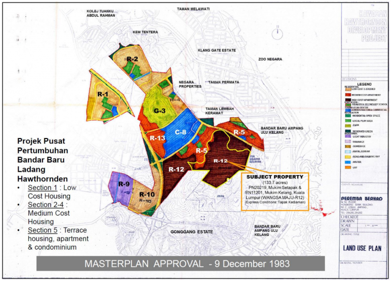
“FIGURE 3: Approved Masterplan for Bandar Baru Ladang Hawthornden” (Peremba Berhad, 9 Disember 1983: Land Use Plan, Kawasan Hawthornden Development Project @ ERINCO Sdn Bhd @ Enviro Knowledge Management Center (EKMC), Jabatan Alam Sekitar, Julai 2017: |"Environment Impact Assessment Report: Proposed Residential and Commercial Development On Lot 26413 Mukim Setapak and Lot 3538 Mukim Ulu Kelang, Kuala Lumpur For Nova Pesona Sdn Bhd:").
Bandar Baru Ladang Hawthornden telah dirasmikan oleh Perdana Menteri ketika itu, Tun Mahathir Mohamad, pada 26 Februari 1984. (PERDANA DIGITAL, Pejabat Perdana Menteri: |"PERASMIAN BANDAR BARU DI LADANG HAWTHORNDEN").
“In 1983, four rubber plantations went through compulsory government acquisition under the then-young Prime Minister, Tun Mahathir.[6] The land acquisition was exercised to tackle the urbanization problem of that era – squatters and insufficient housing for migration of people from the rural area to Kuala Lumpur:
* Ladang Hawthornden
* Ladang Gonggang
* Ladang Kent
* Ladang Wardieburn.
All four plantations were then reclassified and rezoned as “residential lands” - these parcels of lands are then sold to developers.
The vast plantation area - then converted to suburbs - was named Wangsa Maju, the shortened version of Titiwangsa Maju.
One of the plantations – Hawthornden Rubber Estate Company, owned by famous Loke Yew[7] – included plots of lands of the BUKIT DINDING we know today. All of the estates were rezoned as residential, including this plots of land on the hill.
The incidents of notorious landslides of Highland Tower (1993) and Bukit Antarabangsa (2008) had halted slope developments throughout the country. Nevertheless, it is remained unknown why the land plots zoning for slopes of Bukit Dinding (and many other hills in the country) was never rezoned until today.”
(Sumber: Wikipedia: Bukit Dinding: "History").
1983-1995: Gonggang Estate Menjadi Setiawangsa
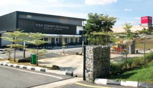
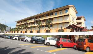
Kiri: Pusat Komuniti Setiawangsa. Tengah: Sekolah Kebangsaan Setiawangsa. Kanan: AEON AU2.
Sepanjang tahun 1983-1995, Ladang Gonggang Estate, termasuk kawasan kaki dan lereng sebelah barat daya Bukit Dinding, mula dibangunkan oleh syarikat Island & Peninsular (I&P) Group Sdn Bhd, kemudiannya dikenali sebagai “Taman Setiawangsa”. Peringkat terakhir pembangunan ini ialah Puncak Setiawangsa, dan disiapkan pada tahun 1995:-
“Nama Gonggang kali terakhir digunakan pada tahun 1980an apabila pihak kerajaan melalui syarikat pemaju I&P mula untuk memajukan kawasan yang dikenali sebagai Gonggang Estate atau Ladang Gonggang. … Kampung-kampung kecil yang berada di Ladang Gonggang ini dipindahkah ke Perumahan Kos Rendah yang terletak di Keramat dan nama Gonggang Estate telah ditukar kepada Setiawangsa selepas ia dibangunkan. Sejak daripada itu, nama Gonggang ini akhirnya hilang di dalam lipatan sejarah buat selama-lamanya. Nama Kg Gonggang juga kini telah hilang dan diganti dengan Kg Datok Keramat dan tiada lagi nama Gonggang disebut kecuali di dalam Sejarah Kuala Lumpur. Adalah dipercayai nama Jalan Enggang yang terletak di persimpangan Jelatek / Keramat adalah berasal daripada nama Gonggang dan ditukar oleh pemaju atas sebab yang tidak diketahui. Walaupun nama Gonggang ini telah berkubur, namun begitu sejarah nama Gonggang masih terpahat di dalam dokumen lama Kuala Lumpur dan menjadi sebahagian daripada sejarah Wangsa Maju yang menjadi salah satu daripada daerah yang termaju di Bandaraya Kuala Lumpur ini.” (Budak Wangsa Maju, 23 September 2018: |"Gonggang: Nama yang hilang di Setiawangsa").
““Setiawangsa caters mainly for the upper-middle to upper class. The terraced houses there, especially in Puncak Setiawangsa, are priced from RM700,000 to RM1.5 million while the semidees and bungalows cost RM1.5 million to RM2 million and RM3 million to RM7 million respectively,” says LaurelCap Sdn Bhd executive director Stanley Toh. “Thus, only a certain income group can afford the properties there.” The non-landed residential properties in the area fetch about RM400 psf. According to Toh, Taman Setiawangsa was developed by Island & Peninsular (I&P) Group Sdn Bhd. “Taman Setiawangsa was developed by I&P Group. The foothill and mid-hill areas were developed in stages in the 1980s before work started on Puncak Setiawangsa, which was completed in 1995,” he says. The 100ha suburb comprises about 3,092 residential units, a large portion of which are freehold, he adds. According to Metro REC Sdn Bhd managing director Ng Weng Yew, Setiawangsa is also the operational base for multinational corporations such as Texas Instruments Inc and pharmaceutical company Fidin Universal Sdn Bhd. “Setiawangsa is also well known for Bukit Dinding, a hill that houses a 200-acre forest,” says Ng. … “Setiawangsa comprises foothill and mid-hill areas such as Taman Setiawangsa, Puncak Setiawangsa and Bukit Setiawangsa,” says Ainnura Aerina Sabirin, who grew up in the area.” (Hannah Rafee @ The Edge Malaysia, January 31, 2019: |"Cover Story: Still a popular address for property buyers").
Perihal syarikat Island & Peninsular (I&P) Group Sdn Bhd:-
- 1981-09-21: Island and Peninsular, pemaju di Pulau Pinang, mengambil alih Associated Malaysian Enterprise (AME) @ Visan Holdings, pemilik Gonggang Estate: “Island and Peninsular, which has so far concentrated its property development activities in Penang, is expanding into Kuala Lumpur. In an announcement yesterday, the group said it is acquiring a land owning company, Associated Malaysian Enterprise Sendirian Berhad (AME), from Visan Holding Sendirian Berhad for $35.5 million in cash less the liabilities of AME as at he completion date. … AME's principal asset is Gonggang Estate - a freehold property of about 253 acres located within the Bandar Baru Ampang-Ulu Klang area. Adjoining its north and north eastern border is Hawthornden Estate which has been acquired by the government.” (BUSINESS TIMES, 22 September 1981, Page 13: |"I & P moves into Kuala Lumpur").
- Pengerusinya (setakat |Mei 1982) ialah Tan Sri Datuk Haji Mohd Sany bin Haji Abdul Ghaffar (|Panglima Angkatan Tentera 1977-1981).
- Sekitar Mei 1983, cadangan pelan pembinaan 6,000 unit perumahan, 150 unit kedai, dan sebuah pusat membeli-belah di Ladang Gonggang telah diluluskan, dan bakal dibina mulai akhir tahun 1983: “I & P said the layout plan for the 102-hectare Gonggang Estate site has been approved. The scheme will comprise well over 6,000 residential units, about 150 shophouses as well as a modern shopping and commercial centre. Building work and house sales by progress payments have been planned for the end of this year.” (BUSINESS TIMES, 26 May 1983, Page 12: |"Island & Peninsular to buy third piece of land").
- Projek tersebut dijalankan sekitar tahun 1984: “Besides development activities in Penang, its previous home base, Island & Pen now has three ongoing projects in Kuala Lumpur - a 6,150-unit housing project known as Gonggang Estate in Ulu Klang, a new township in Kinrara Estate and a head office complex in Kuala Lumpur's Golden Triangle.” (The Business Times, 13 November 1984, Page 15: |"Island & Pen in joint venture to develop apartments").
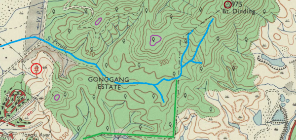
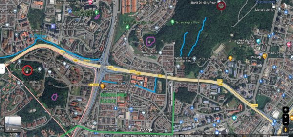
Peta sekitar Gonggang Estate, tahun 1967 (berdasarkan peta Malaysia : Director of National Mapping, 1967: |"Malaysia, Selangor, Kuala Lumpur, Series: L8010, Sheet 94k, 1967, 1:25 000") dan kini (berdasarkan Google Maps). Garis biru: Sungai Peran, anak Sungai Bunus yang merentasi Gonggang Estate (sempadan hijau, iaitu Setiawangsa kini): “Sungai Bunus mempunyai kawasan tadahan seluas 17 kilometer persegi meliputi kawasan Wangsa Maju dan Setiawangsa. Dua anak sungai utamanya ialah Sungai Air Panas yang mengalir dari kawasan tadahan Wangsa Maju dan Sungai Peran meliputi kawasan tadahan Setiawangsa.” (Jabatan Pengairan dan Saliran Malaysia, 2020: |"Laporan Tahunan 2020", m.s.88). Bulatan cokelat: Puncak Bukit Dinding. Bulatan ungu: puncak bukit-bukit kecil, sebagai beberapa mercu tanda kawasan ini. Bulatan merah: Kawasan Perkuburan Loke Yew.
| Laman Utama | Hubungi Kami | ||||||||
| Siri Cebisan Sejarah: | Bangi | Gambang | Hutan | Ipoh | Kajang | Kuala Lumpur | Kuantan | Pulau Pinang | Hubungi Kami |
